
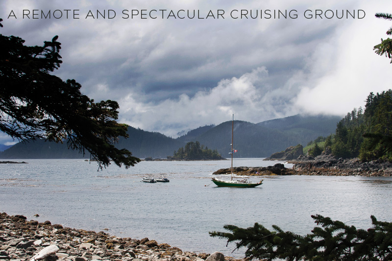
 They will also find some of the Pacific Northwest’s roughest waters and challenging passages. The two trips my husband Steve and I made in our Annapolis 44 sloop, Osprey, were among the most memorable and challenging trips of our 40 years of cruising this coast.
A trip to Haida Gwaii can easily take a whole summer. As you would for preparing for a trip to Southeast Alaska, you need to carry a full set of spares and develop a long-distance cruising mindset. A typical cruise from the Salish Sea requires a two-to-three week journey up the Inside Passage, a day-long crossing of Hecate Strait, time for shopping, repairs, and playing tourist in Skidegate Inlet, followed by another two-to-three week journey into Gwaii Haanas National Park Reserve and Haida Heritage Site. Cruising the archipelago’s west coast can add two or more weeks.
Your cruise may include three weeks, or even more, without access to treated potable water, fuel, groceries, or a garbage drop-off. You need to know how many miles you can cruise on a tank of fuel, how many days you can go on a tank of water, how much food you need to carry, and where you’re going to stow several weeks of trash. When leaving Haida Gwaii, sailboats and slow powerboats must plan for an overnight crossing to the Bella Bella area or a 36-hour trip around the north tip of Vancouver Island to Winter Harbour.
But what you discover when you reach Haida Gwaii is a place like no other on Earth.
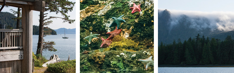
the tall bluffs overlooking Bag Harbor. This harbor is an excellent
anchorage from which to view the wildlife.
Haida Gwaii sits at the very edge of the North American continent and its continental shelf. That location and the 60-mile distance from the mainland gave us the Haida culture and Haida Gwaii’s unique geology and biology. Portions of the archipelago remained ice-free during the last glaciation, creating isolated pockets where plants and animals survived to evolve with unique characteristics. Haida Gwaii’s black bears, for example, are the largest black bears anywhere, and there are unique species of plants and animals found only on Haida Gwaii.
As on islands everywhere, the introduction of non-native species threatens Haida Gwaii. Sitka black-tailed deer, for example, were introduced in the 1880s to supplement people’s diets. Deer numbers have grown to the point that the Park is now undertaking a deer eradication project to limit their numbers.
Members of the Haida Nation have lived on Haida Gwaii for more than 10,000 years. Their numbers before the arrival of Europeans have been estimated as high as 20,000. In their large war canoes, they ranged up and down the Northwest coast, trading with other tribes and raiding villages. Following the first contact with Europeans, Haida art flourished with wealth from the fur trade and new iron tools that allowed the carving of larger and more elaborate poles and other artworks. But smallpox, other diseases, and intertribal warfare took their toll. By the late 1800s, fewer than 500 native people occupied Haida Gwaii. Abandoning their southern villages, the Haida consolidated in Skidegate and Old Masset, on Graham Island, leaving behind their monumental poles and grand houses as reminders of their glory.
After the decline of the fur trade, the islands attracted fishing, mining, and forestry. By the 1980s, the rate of logging threatened the archipelago’s natural environment and the Haida’s traditional resources. Protests from the Haida Nation raised the issue of tribal land rights and attracted international attention. The government of Canada negotiated with the Haida Nation, creating the Gwaii Haanas National Park, jointly managed by the Haida Nation and the government of Canada.
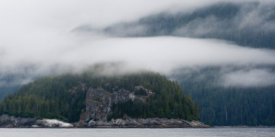
Thanks to Haida Gwaii’s offshore location, the wind blows stronger there, fog is more frequent, and temperatures are milder than on the mainland or Vancouver Island. July is the driest month, while August is the warmest. A backbone of mountains running down the middle of the archipelago shields Haida Gwaii’s east coast from the worst of the precipitation, making it drier than the west coast (52 inches vs 168 inches). During summer northwesterlies, neither coast is likely to have rain but the west coast is likely to have more fog.
Skidegate Inlet, between Graham Island on the north and Moresby Island on the south, is Haida Gwaii’s primary center of commerce. The Inlet has two marinas: Sandspit Marina on the Inlet’s south side and Queen Charlotte City Harbour Authority on the north. The Sandspit Marina is modern and spacious with a fuel dock, showers, and power, but other than being close to the Sandspit Airport for crew changes, the Sandspit village itself offers few amenities. At Queen Charlotte Harbour you may need to raft or even anchor. The village of Queen Charlotte (known as Queen Charlotte City until residents became tired of tourists asking, “Where’s the city?”) offers a grocery store, a hardware store, a Visitors’ Information Centre, a hospital, clinic, pharmacy, restaurants, coffee shops, and gift shops. You can also rent a car for side trips to Old Masset, Tow Hill, or other tourist destinations.
The north side of the Inlet is home to the Haida Heritage Centre at Skidegate. A visit there is the best way to acquaint yourself with Haida art, culture, and history. Recently carved poles grace the Haida Culture Centre, evidence of a renaissance in the Haida culture. Don’t look for public transportation to the Centre, but you can hitchhike or anchor off Jewell Island and take your dinghy ashore.
Once you leave Skidegate Inlet and head south down the east side of Moresby Island, you enter an area of scenic anchorages, forested islands, and ancient village sites. Prevailing westerlies ensure much of your trip down this coast will be in protected waters, with only short trips along more exposed headlands including Skedans Point, Lyell Island, Scudder Point (with wild rips not noted in any guide), and the stretch along Benjamin, Goodwin, and Ikeda points. The longest open water stretch will be the 40 nautical miles from Skidegate Inlet to Skedans, just north of the Park.
Five sites, four in Gwaii Haanas Park and one (Skedans) on a separate Haida National Park Reserve, are manned by Haida Watchmen. The Watchmen are employed by the Park and will welcome you and give you a tour. They live onsite during the summer. Regulations allow only 12 visitors at a time at each site. Call on VHF channel 6 for permission to come ashore.
Because the Haida built their villages for access by canoes, not modern cruising boats, their village sites can be poor anchorages, open to weather, and clogged with kelp and rocks. Up-to-date charts are critical. Overnight anchorage at the managed sites is neither encouraged nor practical. Few cruisers will have time to visit all the east coast’s many anchorages, but most will want to see all the managed sites. Plan your cruise around them and choose other anchorages for their features and convenience to the sites.
Skedans has original carved memorial and mortuary poles and one of the most spectacular settings: a park-like area on Skedans Point under the shadow of high basalt cliffs.
Tanu (T’aanu Linagaay) lies 11 miles south, inside the park. You will walk on mossy trails lined by clam shells among what was once a thriving village with large community houses. The Watchmen will show you how to recognize house sites from their house pits and fallen house poles. From Tanu you have the option of anchoring nearby before heading southeast to the next site, Windy Bay, or heading west to explore the marshes and creeks of the tree-lined harbors of Anna and Echo harbors. Watch for Sandhill cranes along the shores and eagles nesting in the trees.
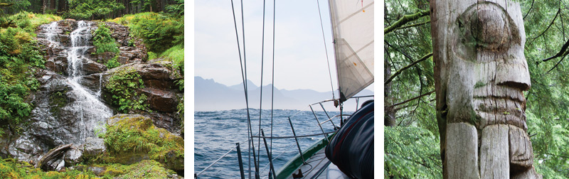
Windy Bay (Hlk’yah Linagaay) has an impressive stand of old-growth forest and interesting recent history. At Windy Bay, the Haida Nation and Hadia Gwaii residents made their stand in 1987 against massive clear cutting that was destroying their homeland’s environment. A newly constructed longhouse commemorates the event. Watchmen will explain the interdependence of their people and the forest and point out culturally modified trees (CMTs) — cedar trees with strips of bark removed for weaving. Other trees show the marks of old burns where canoe makers tested them for potential as canoe logs. Remnants of clear cuts in surrounding hills are sobering reminders of what Haida Gwaii would be like today without the vision and perseverance of the Haida Nation.
Hot Spring Island, (Gandll K’in Gwaay.yaay) six miles south, lost its hot springs in an earthquake in 2012. Geologists are cautiously optimistic the springs will return, but for now the only warm water is below the high tide mark. But the view of green islands and blue water from the island’s hiking trails are worth the stop.
As the crow flies, it’s 30 nautical miles from Hot Spring Island to the next managed site, SGang Gwaay on Anthony Island — many more miles if you have the time to explore the waterways in between. It’s worth the extra time. You can scramble up the high granite walls of Sac Bay, kayak through Dolomite Narrows to view the area’s abundant and colorful sealife, explore the remains of a mining town in Ikeda Cove, watch the fog pour over the island from the west in Slim Inlet, and spy deer gambol on the beach at Poole Inlet.
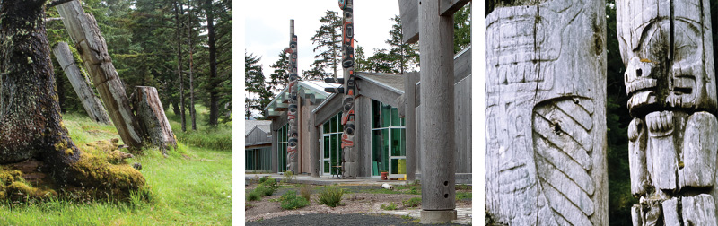
SGang Gwaay, the fifth and best known of the managed sites, is located off the exposed southwest coast of Moresby island. The cluster of standing mortuary poles, longhouse sites, and middens have earned it the status of both a National Historic Site and a World Heritage Site. We have seen it twice. The first time we approached S’Gang Gwaay from the east, just in time to see the stand mortuary poles emerge from the fog. The second time, we approached from the northwest to see the poles gleaming in the sunshine. Both times the first sight of the cluster of poles made my heart jump. Walking among them, I felt the need for silence. I felt the presence of former villagers’ ghosts hovering nearby.
Boaters who brave the tortuous and current-swept Skidegate Narrows to head south down the west coast of Moresby Island will find a mountainous, rockbound coast exposed to the full fury of the Pacific and indented by a series of inlets, sounds, and bays. Although much of the coast is in Gwaii Haanas National Park Reserve, you’ll see few other boats. If that is unnerving, know that if an extreme emergency occurs, there is good VHF reception with Prince Rupert Coast Guard.
Crossing Hecate Strait
Hecate Strait, between the mainland and Haida Gwaii, is famous for its strong currents, high winds, and shallow waters; a combination that conspires to create steep seas and a rough crossing. If your route takes you across Hecate Strait, the choice of a crossing location will be one of the most important decisions of your trip. Because Hecate Strait narrows as it goes north, the farther north your departure point, the shorter the crossing, and, assuming prevailing northwesterlies, the easier the passage. Possible routes:
Browning Entrance area to Skidegate Inlet: Larsen Harbour (60 nm) or Spicer Islands (69 nm). This is the most common and easiest route. Dogfish Bank halfway across provides partial protection from the seas, and sailboats will be slightly off the wind. Arriving at Skidegate Inlet puts you in a position for a southbound cruise through the Park.
Points farther south on Hecate Strait to Rose Harbour: Leaving farther south and landing at Rose Harbour near Haida Gwaii’s southern tip can take a day or two off your trip. Landing at Rose Harbour, or at any location in the Gwaii Haanas Park, requires a permit in hand and self-orientation with a DVD. Watch the weather carefully when taking this route. It can put you in the full brunt of northwesters barreling down Hecate Strait.
Arriving at Rose Harbour in the south end works especially well if you plan on cruising both east and west coasts of Moresby Island. It allows you to go north up the east side and south down the west side. Options for departure include Borrowman Bay on Aristazabel Island (74 nm) and Gillian Harbour (73 nm) in the Estevan Group.
Open Water Routes
Southern Ports to Rose Harbour: With the right boat and the right wind (a 15-knot southerly would be perfect), you can depart from any number of ports from Port Hardy (157 nm) to Seaforth Channel (103 nm).
The Ocean Route: If you’re prepared for an extended ocean sail, it may be faster to sail up the west coast of Vancouver Island and across Queen Charlotte Sound.
The coast’s smaller bays and inlets are unsurveyed (they are shown as white on the charts) and lack navigation marks. Entering them is a daunting prospect, particularly in fog with strong or gale-force westerlies behind you. Keep a sharp lookout and be ready to change course quickly. The Canadian government’s reference, Sailing Directions, lists rocks and reefs reported by fishermen over the years. Sketches in Exploring the North Coast of British Columbia: Blunden Harbour to Dixon Entrance, the Douglass’ cruising guide, are invaluable, although not always 100% accurate. Use your own best judgment.
It’s about 85 nautical miles from the west end of Skidegate Narrows to Houston Stewart Channel and Rose Harbour. With a strong wind behind you, you could sail the coast in two to three days. With a wind against you, it might take you a week or more. But the coast boasts many anchorages worth visiting, including Buck Channel, the site of the ancient village site of Chaatl with two magnificent standing totem poles, and Sunday Inlet with its awe-inspiring Pinnacle Rocks. As you cruise down the coast, albatross soar overhead and fog may obscure the land, making glimpses of the rockbound coast even more awe-inspiring.
In theory, you could sail north from Rose Harbour up the west coast of Moresby Island and east through Skidegate Narrows, but the eastbound transit of the Narrows is considered riskier for sailboats. Visiting Skidegate Inlet before transiting the Narrows also allows a visit to the Sandspit Coast Guard Station to check on the status of navigation marks and discuss your approach to the Narrows.
Most cruisers will make Rose Harbour their last stop in Haida Gwaii. A former industrial whaling center, Rose Harbour has some of the few privately owned properties in the park. An afternoon spent poking among the old machinery and structures of the whaling center is intriguing. This is a place to relax – to make last minute repairs for the return trip, to compare stories with other boaters, and perhaps to eat at one of the several guesthouses. It’s also a place to wait for the right weather. We waited out a southerly gale there on our first trip and a northerly gale on our second.
Our two trips to Haida Gwaii have been among the most interesting and rewarding of our Northwest cruises. We learned about a culture that almost vanished, saw and admired the famous monumental Haida art, enjoyed fantastic scenery and wildlife, and tested our navigational skills to the utmost.