
the story of one of his Puget Sound deliveries.
Jump inside the mind of a pro to see how it’s done right.
 I park my car at Kenmore Air’s South Lake Union terminal, and my friend (who we will call Teresa) and I walk with our overnight bags to Chandlers Cove. It is 0700 hours on a Wednesday morning. I got a call the previous Saturday from a client asking if I could reposition his 62’ Tollycraft from Lake Union to Roche Harbor. I told him I would be happy to as soon as I found some suitable weather.
I immediately went to the National Weather Service Seattle website to look ahead (weather.gov/sew). The National Weather Service forecasts out five days. The inland waters of the Pacific Northwest is divided into six different areas: West, Central, and Eastern Straits of Juan de Fuca, Northern Inland waters including the San Juan Islands, Admiralty Inlet and Puget Sound, and Hood Canal. It was obvious at first glance that the next three days would be very windy with two separate systems coming ashore. Wednesday, however, looked promising. I decided to wait and continue to watch the forecast.
By Monday, the forecast for Wednesday was good for Puget Sound and the San Juan Islands, five to 15 knots for both areas, but the Strait of Juan de Fuca was still forecast to be at 20 to 30 knots from the west. I know from experience that this would produce a chop of at least three to five feet. With high terrain on both sides, the Strait of Juan de Fuca is a natural wind tunnel as is the Strait of Georgia, with Vancouver Island on one side and the mainland on the other. Both bodies of water are known for their high winds.
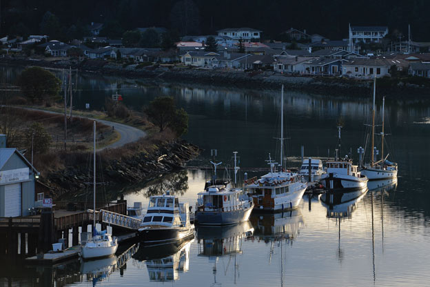
on trips up through Puget Sound – it’s protected, calm, and has a great place
to stop built in. (Photo: July7th/iStock.com)
We are lucky here in Washington because we have a protected option that lets us get around the Strait of Juan de Fuca when it experiences high winds. This option is the Swinomish Slough, connecting Skagit Bay with Padilla Bay, which allows us to completely circumnavigate the Strait. I routinely run into boaters who have yet to discover the Swinomish Slough option that has the bonus of running through the charming town of La Conner.
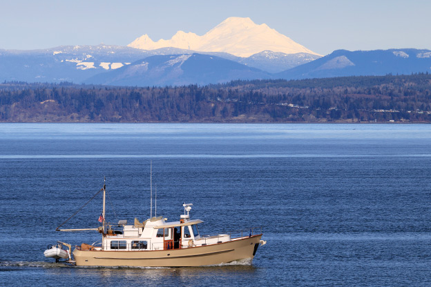
Running from Shilshole Bay Marina directly to Roche Harbor via Port Townsend and crossing the Strait of Juan de Fuca is 68 nautical miles. At ten knots, including the Ballard Locks for those moored on Lake Washington, the route can be done in about eight hours or so or on a good day. Being the cautious and prudent mariner, however, I opt to go the inside route for my delivery; up the east side of Whidbey Island, past La Conner through the Swinomish Slough, and then west through the islands to Roche Harbor.
The Tollycraft, at least this particular vessel, cruises best at 10 knots. From South Lake Union to Shilshole Bay Marina through the Ballard Locks is at least one hour. Shilshole to the south entrance of the Swinomish Slough is 46 nautical miles or about four and a half hours. It’s a good hour through the slough, mostly a no-wake zone. From the north entrance up to Anacortes and then across to Roche Harbor is 30 nautical miles or about three hours and then about 30 minutes to the marina secured to the dock. All told, taking the scenic route past La Conner would take at least 10 hours. That would make for a pretty long day and too late to catch a Kenmore Air flight back. I opt for an easier trip, staying the night in La Conner and completing the trip in two days instead.
I check the forecast weather through the National Weather Service every day leading up to my Wednesday morning departure. My last check was earlier this morning just before we left to make sure the forecast had not changed. With our two mountain ranges and varied topography, we have many microclimates in the Pacific Northwest.
It is a very difficult area to forecast, and it is not uncommon for winds to change at the last minute. I also paid the boat a visit over the weekend. I started up both engines and gensets, plus exercised the controls and thrusters to ensure everything was operating properly. I verified the amount of fuel onboard. This trip will be approximately 10 hours at 10 knots, burning about 17 gallons per hour. That is 170 gallons of required fuel. I want at least 200 gallons onboard when I arrive, so I need at least 400 gallons onboard before taking off.
With a good forecast ahead for the next two days, my assistant and I step onto the boat in Chandler’s Cove and begin preparing her for departure.
First thing, I go to the AC power and DC power breaker panels, turning on the heads, freshwater pump, and any interior lights I may need. Pieces of equipment that can run on their own, like the heads and water pumps, should be left off when the boat is unattended. Next I hit the breakers for all electronics, stabilizers, and thrusters. My next task is to start a generator, switch from shore power, and bring in the shore power cord. I then turn on all electronics that I will use and ensure everything is running. I don’t want to be trying to set up screens and the like while I am focused on navigating Lake Union and the Ship Canal. Once I feel the boat is ready to go, I start the main engines and let them warm up for a few minutes.
The boat is tied up starboard side to the dock with a 10 knot off-dock wind. I determine that we can safely remove the spring lines first. I instruct Teresa to untie the bow line first, throw it onboard, and move aft to take the stern line. I hold the bow to the dock with the bow thruster while she unties the stern line and steps onboard. With an “all clear” from her, we are on our way.
Turning to the northwest to head across Lake Union, I put Teresa on the helm so that I can get set up for the Ballard Locks. Heading outbound, I know that we will more than likely be on the starboard side, whether it is the small or large lock. I bring the fenders on the starboard side from the waters edge up to protect the outermost part of the boat. I then set a couple of fenders on the port side just in case. I rig the bow and stern lines for both sides for the small locks and set out my 50-foot lines fore and aft for the large locks just in case that is where we end up. One should be prepared to be directed into either the small or large locks.
Leaving early on a Wednesday morning has paid off. Five minutes after arriving at the Ballard Locks, I get the green light for the small lock. I instruct Teresa to standby the aft line as we enter the chamber. The lock attendant gives me the “right there is good captain” and I bring her to a full stop. Teresa puts her line around the bollard on the top of the sleeve and makes it fast to the boats cleat. I run forward and do the same with the bow line.
On the way down I tell Teresa that the lock attendant will tell her when to remove the line. I will do the bow line; which will be first once the gate has opened. As we move out of the locks, I feel a sense of relief that the step has been completed. Even I have a little anxiety when it comes to the Locks. Now I can look forward to the rest of the trip.
With the lines and fenders up on deck, we idle out of the channel and past Shilshole Bay Marina. After passing the Sea Buoy, I turn her to the north. I use my chart plotter and a predictor line that I set up to steady the vessel on a course that is parallel to the edge of the outbound vessel traffic lane. The predictor line is a line that extends from a vessel depicted on the chart plotter. This line represents one’s Course Over the Ground or COG. The length of the line is usually a factor of time, and I typically use 30 minutes. The predictor line is probably my most useful tool and feature of the chart plotter. If I want to navigate the vessel to a particular point on the chart or parallel a particular feature, I use the predictor line to do so.
Once we are settled on our initial course northbound in the Sound, I settle into my transit routine. It doesn’t matter whether I am in Puget Sound or 20 nautical miles offshore, my underway watch routine is the same. I monitor my navigation to ensure that we are on track or on the proper heading. I scan the water to look for debris or other hazards, like traffic. I do a quick scan of the engine instruments every few minutes and take a peek into the engine room every few hours, always looking, listening, and smelling for anything that may be out of the ordinary. Most of the issues I have found in the past have been through smell. Every liquid on board the boat has its own particular smell, and learning not only how your boat sounds, but how she smells, can be helpful.
After about 30 minutes into our journey, we approach Point Wells, just south of Edmonds. I start looking ahead at where the two ferries on the Edmonds-Kingston ferry run are and what they are doing. I can see that there is one docked in Edmonds. As I approach, I watch very carefully for it to depart and review the rules of the road in my head. If she pulls out ahead of me, crossing from right to left, I am the give-way vessel and must alter course to starboard and pass behind her. And wouldn’t you know it, just as I am off the marina, she sounds her whistle and starts to pull out. Being this close to her and the beach, I opt to just slow down for a few minutes to let her pass in front of me.
An hour past Edmonds, we pass the Clinton-Mukilteo ferry run without any encounters and continue up Possession Sound towards La Conner. As we approach Skagit Bay, I am careful to stay close to the Whidbey Island side to keep a series of red buoys on my starboard side. These buoys mark the channel that you follow to the south entrance of the Swinomish Slough.
The south entrance to the Slough is very well-marked by red and green buoys in a range that keeps you in the center of the channel. As I make my turn into the channel, I start to think about the guest dock and what side we will tie up on. The thing about the Swinomish Slough is there is always a current running either north or south. A vessel acts like a weather vane. All the boat’s draft, rudders, and running gear are aft. It is much easier to back into the wind and current than with the bow to the wind and current.
As the channel makes its first turn to the north just south of La Conner, I determine that the current is flowing south. The guest moorage’s long side runs parallel to the channel. This means turning around, putting my stern to the current, and tying up port side. I kindly ask Teresa to start moving fenders and lines to the port side.
Arriving at the guest moorage, I pick a suitable open stretch of dock and turn the boat around to face south with my stern to the current. I pick a reference point on the dock that is straight over from where I am standing in the pilot house. Stemming (aka, holding position against) the current and holding that reference point, I angle the stern slightly towards the dock. This has the effect of using the current to slowly move me towards the dock. Teresa stands by on the swim step with the stern line in hand. As I get to within a few feet of the dock, I flatten out my approach and allow the boat to gently meet the dock. Teresa steps off and immediately gets the stern line secured. Because the boat is now tending down current on the stern line, she can walk up, take the bow line and secure it as well. Had we tried to moor bow to the current, the boat would have been very difficult to control.
It’s about 1430 hours, the boat is plugged in and everything shut down. The next National Weather Service forecast will be issued at 1500 hours. The forecasts are issued four times a day at 0300, 0900, 1500, and 2100 hours. I review the next day’s plan. It is 30 minutes to the north end of the Slough and then three hours at 10 knots to Roche Harbor. If I leave at 0800 hours tomorrow morning; I should be there and tied up by noon. Plenty of time to buy my lovely assistant lunch and catch Kenmore Air back to Seattle.
At 0730 hours the next morning the genset and engines are running, the shore cord is stowed, and the electronics fired up. The morning forecast for the San Juan Islands has not changed from last night’s,with winds from the northwest at ten knots. The current in the slough is now flowing from the south, right on my bow. This will be a bit trickier since as soon as the bow line comes off, the current will want to pull the bow. Teresa and I remove both spring lines, leaving just the bow and stern lines. As I hold the bow to the dock with the bow thruster, Teresa quickly removes the bow line and throws it onboard. Running aft, she takes the stern line, steps onboard, and gives me a loud, “Clear!”
I thrust the bow to the starboard and give the starboard engine a shot ahead to push my stern out and we are off. Moving out into the middle of the channel, I split the engines, spin her around in place, and we are on our way to Roche Harbor.
Whether your trip is 45 nautical miles, 450, or 4,500, proper planning, preparation, and sound safe decision making with regards to the weather is key to your safe and enjoyable boating.