
By David Burch, Starpath Navigation
We have been working on using Google Earth (GE) for practice with echart navigation, which led to a couple short videos on the process listed at the end here. In this process we discovered a remarkable NOAA service that I am embarrassed to say that I did not know about till now. I am not sure how long it has been online, but it is there now and works great. It is part of their new products on seamless display, that we discuss more at the end here. The GE feature of that program is the subject at hand.
With this easy to use utility you can see at a glance all 2100 NOAA charts outlined on the GE world map, with the ability to actually view the individual charts, with or without a border, as well as a very quick way to download the RNC echart of any one of them.
The process is explained on a page of the NOAA site called Seamless Raster Navigational Chart Server & Web Map Services, but you pretty much have to know it is there to find it. Once there the main link that is needed is the Google Earth kmz file, called NOAA_RNCs.kmz.
When you click that link it will download the 340-kb kmz file to your downloads, and then just open Google Earth and drag and drop that file onto the GE world. You will see something like Figure 1.

Then just zoom to the region you care about. Below is the region we use for our coastal nav training program near the chart 18465. In Figure 2 I have rolled the cursor over the 18465 boundary, which highlight it, then clicked the boundary line to pop up the control panel shown.
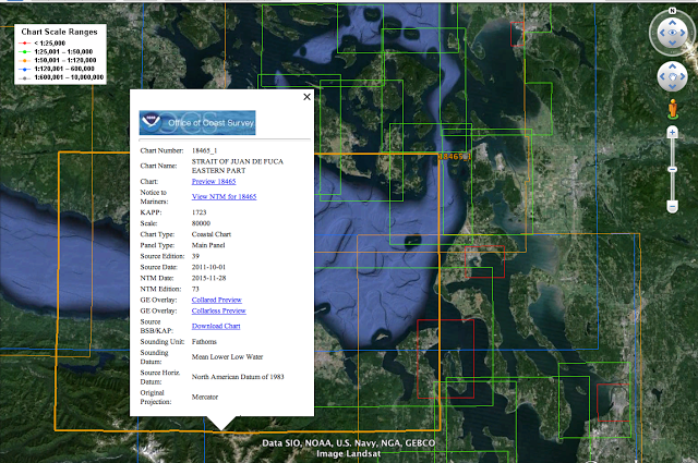
At this point you can start experimenting with the options. The “collarless preview” loads the chart without the borders; the collared preview shows a full copy of the paper chart with all borders and scales.
Below is a short video about this process, showing some of the neat features it offers, including how to do a a direct download of any RNC echart.
We also have an earlier video that shows a bit more of using the GE display for practice with echarts, though for work on 18465 it would be best to use the above, latest chart rather than the 18465TR we discuss in this older video.
As noted earlier, NOAA is getting started with their own version of this type of display from their own server, which has a lot of potential, but it is not yet nearly as convenient as the GE version. Especially promising is thecounter part they have for vector charts, but this one is even less developed than their seamless raster chart. All in all though, NOAA has been doing a tremendous amount of development of their site with many benefits to mariners.
3 comments
Can’t seem to be able to open the charts themselves on an iPad. No curser to point and click. The kmz file overlays the goggle earth map.
Can this be used on an iPad or does the program require a computer?
Have you subsequently managed to integrate CHS RNC or ENC charts into Google Earth? The NOAA charts work great, but I spend a lot of time farther north in BC and would really like to have those charts integrated as well.
Thanks.
How do you remove these from Google Earth? Great if needed, but annoying if not.