
Ed note: The Internet is abuzz with the news that the wreck of one of the Franklin Expedition’s ships, either the Erebus or the Terror, has been found in Canada. This is a major find for North American historians and Canadian Prime Minister Stephen Harper who has championed the search. (The CBC has a great timeline here.) I was intrigued enough to write a about the search (Wave Writer, Northwest Yachting October 2011.) We’re lucky that Marianne Scott took an interest as well. Here is her well researched piece, Arctic Expedition, which first appeared in Pacific Yachting Magazine. –KH
Arctic Expedition
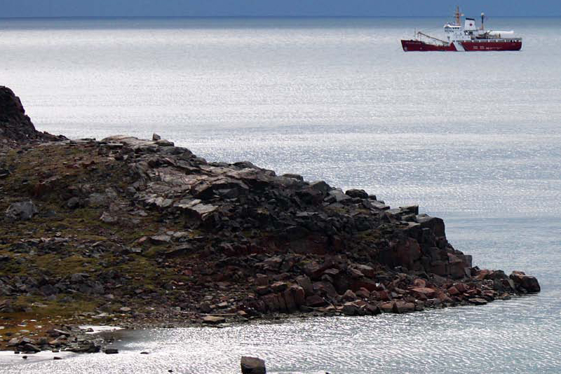
CCGF Sir Wilfred Laurier
On July 4, 2012, the steel icebreaker CCGS Sir Wilfrid Laurier left its homeport in Victoria Harbour and began its trek to the Northwest Passage. By the time the 83-metre ship returned to its berth, it had navigated 11,247 miles. The goal? To service navigational equipment and conduct scientific tests on the way to the Arctic and back, but most of all, to conduct the Arctic Charting and Mapping Pilot Project and, perhaps a more glamorous target for history buffs, locate the Franklin Expedition’s lost ships.
It’s the fourth such expedition—similar efforts were made in 2008, 2009 and 2011. All have focused on surveying and charting the seabed and coastlines, conducting archaeological investigations and searching for the HMS Erebus and HMS Terror, the ships that brought Sir John Franklin to what is now the Canadian Arctic.
The 2012 expedition was more intense and brought more equipment, technology, vessels and people together than ever before in a specific part of the Arctic—the area west of King William Island in Victoria and Alexandra Straits. Charts for these waterways show sparse soundings. In addition, Parks Canada wanted to explore more territory and re-examine Franklin and Inuit sites. It’s in this region that Inuit oral testimony and ocean drift patterns might pinpoint the graves of the Erebus and Terror.
Although the 2012 hunt again failed to locate the two mid-19th century ships, the surveys narrowed the areas where future searches can be made. The terrestrial archeologists, Dr. Douglas Stenton (Gov. of Nunavut) and Dr. Robert Park (U of Waterloo), were more successful and found additional artifacts left behind by Franklin’s crew, including cloth, a button and square nails.
Sir John Franklin’s Arctic Journey Traversing the Northwest Passage—the “Arctic Grail”—and scientific exploration motivated Franklin to start his third expedition in 1845. His crew numbered 134 and he stowed provisions for three years. His stout ships—100-foot former bomb vessels— had sailed Arctic waters before and were equipped with advanced technology, including auxiliary-steam screw propulsion systems.
But the ships were left icebound in 1848, and no one from the expedition, including Franklin, was ever heard from again. Stimulated by stories in the Victorian media, Lady Jane Franklin’s resolute efforts and a £20,000 reward, many attempts were made to discover their fate. It was only in 1859 that Lt. William Hobson confirmed their death after finding a note describing starvation and despair in a cairn on King William Island. Today, their saga still resonates. In 1992, the Government of Canada declared the missing wrecks a “national historic site”—the only such designation for undiscovered artifacts.
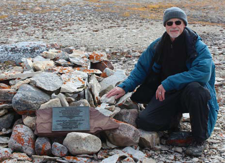
Archeologist Doug Stenton
A Cooperative Venture Captain Bill Noon, a 31-year Coast Guard veteran stationed in Victoria, skippered the Laurier, which served as mother ship for the Hydrographic Services’ surveying and charting. When off duty, Noon explores B.C. waters in the well-known Messenger III, a 50-footer built in 1947, once serving as B.C.’s missionary ship for the Shantyman’s Christian Association near Tahsis. The Arctic trip was Noon’s sixth and he joined his ship at Gjoa Haven on King William Island.
“The Coast Guard has served here for decades,” the lanky, 1.95 metre-tall mariner said. “We’ve operated icebreakers here and backed the Distant Early Warning Line until its decommissioning. We support shipping safety, aids-to-navigation, icebreaking and search-and-rescue missions.”
“We worked with many other organizations in 2012,” said Noon, as he counted them off his fingers. “They included Parks Canada, the Hydrographic Service, National Defence, Canadian Ice Service, Canadian Space Agency, UVic, and, let’s see, the Government of Nunavut. Each of these groups had competing tasks and interests, but everyone worked well together. That said, my most challenging job was to keep them all safe.”
The Laurier carried a slew of equipment. The on-board Zodiacs transported people ashore and serviced beacons. “We overhauled 80 fixed-navigation aids, moved three range-marker sets and placed nine navigation buoys,” said Noon proudly. “We also deployed and recovered several ‘Sea Spider’ tidal gauges that measure the water column. These measurements are essential for chart making.”
Conducting the Search A newly revamped research vessel, the 19-metre Martin Bergmann, operated by the Arctic Research Foundation, joined the Sir Wilfrid Laurier. From the Bergmann, the crew deployed digital side-scan sonar “towfish” to look for wood debris and metal components that might have survived scouring, deep ice packs. Parks Canada’s marine archaeologists Ryan Harris and Marc-André Bernier watched in real time as the oceanfloor images streamed in from the towfish.
So how will detailed charts be developed for this region? “Data is collected with various technologies and techniques,” said Noon. He pointed out that the Space Agency’s optical satellite imaging had previously identified land/ocean boundaries. Then a Beechcraft airplane used light to measure water depths, a technology called LiDAR (Light Detection And Ranging).
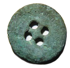
Copper Button
“As long as the sky and water are clear and ice has departed, LiDAR can quickly collect mapping data,” said CHS’ George Schlagintweit. “That allows the Laurier with its six-metre draft to navigate more safely.” Environment Canada videographers supplemented the satellite images with additional shoreline details they photographed from the Coast Guard’s Messerschmitt 105 helicopter.
Whenever winds blew less than 25 knots, the Canadian Hydrographic Service’s Andrew Leyzack and other hydrographers lowered two 24-foot Hourston Glascraft, multi-beam, sonar-equipped vessels Gannet and Kinglett into the ocean. To scan the seabed, the vessels “mowed the lawn,” moving back and forth in a grid pattern in slightly overlapping straight lines. The sonar shoots out a 120° fan-shaped beam that traces the contours of the ocean floor. The collected data then incorporates current, tide and aerial data and after multiple reviews, becomes a chart.
UVic Tests its AUV During the 2012 expedition the University of Victoria also tested new technology by deploying its autonomous underwater vehicle (AUV), a Bluefin Robotics product nicknamed “Mano” (Hawaiian for shark). The robot facilitates research into sensor development and can ensonify the seabed. Alison Proctor, a UVic mechanical-engineering doctoral candidate, spent four weeks aboard the Laurier testing the yellow, torpedo- shaped vehicle.
“Mano worked well despite the fact we had no parts store and had to make adjustments on the fly,” said Proctor. “We learned a lot. The harsh Arctic is an important frontier for us and we didn’t know how far we could push the navigation system. It’s a great test bed for developing new technologies.”
She explained the 3.5-metre robot’s computers are programmed to dive down, and follow the ocean floor’s contours at a predetermined altitude. The AUV is rated to depths of 200 metres—vastly more than a surveying ship and much deeper than divers could go. Each of its side-scan sonar transducers has a 75-metre wide beam and the data gathered is compatible with that collected by Parks Canada and the Hydrographic Service.
“Mano isn’t affected by surface conditions like a boat,” she added. “Although we had to monitor it in a sometimes bouncy five-metre tender. And of course, we had to launch and retrieve the 204 kilogram robot from two different ships, each creating its own challenges.”
What They Found “We saw only a bit of rotten multi-year ice during our work here,” said Noon. “Overall, 2012 was the second lowest in ice accumulation. It snowed on August 24. We had fog and high winds. But in the past couple of years, it’s been a bit like the Gulf Islands. We saw sailboats coming out of the fog. About 20 to 30 yachts go through here every year. And there are more and more adventure ships. Even The World, the residential cruise ship, came through here in 2012.”
“We had an additional logistic challenge on this trip,” Noon added. “The CBC’s Peter Mansbridge wanted to report live on the Franklin search. We’d planned his trip for months, but the weather was rough with 25 knot winds. He finally arrived on a Twin Otter with fat tundra tires that allow planes to land in Arctic terrain, but only if the ground is flat and hard-packed. Fortunately, it worked.”
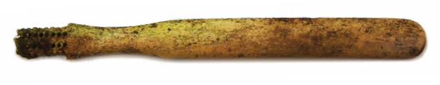
Bone Toothbrush
Mansbridge was choppered to the site where Stenton and Park were searching for artifacts—an area where a dozen of Franklin’s crew had died. They’d found a tooth, a button and bones. Mansbridge, a wannabe archaeologist in his youth, got involved in the hunt and found a bone toothbrush. “It was very exciting,” he said later during an interview.
For Captain Noon, these finds made the trip personal for him. “I’m a history nut,” he said. “I spent my life reading about the search for Franklin. For 164 years, it’s been the holy grail of marine archaeology. When I touched that brass button, it gave me a real feeling of history. A real connection.”
He also was moved by a live chat with the descendants of Sir Francis Crozier, Franklin’s second-in-command. “Many people in England participated. We chatted with the family members. It really personalized the search for me.”
So will they ever find those legendary ships? “We don’t know,” said Noon. “Pack ice can scour the seabed and destroy or bury the wrecks. But I still think that at least one of them will be located. For now, the quest continues.”