We wrap up another interesting week for weather in the Pacific Northwest with morning fog, clearing afternoons and temperatures still in the 70° range. Amazing. That however is all going to change as the first of a series of fronts make their way onshore tonight and early next week it’s going to get pretty wet. This weekend however still looks pretty nice.
I also had a chance this week to go to the Emergency Management Weather Workshop at the National Weather Service Forecast Office at Sand Point. There we got briefed on what to expect this coming weather and what resources are available to us in case of extreme weather events like lowland snow, heavy rain resulting in potential flooding, and high wind warnings any of which can lead to the activation of the Emergency Alert System. Northwest Yachting is now signed up for this so in the event of a high wind warning, we will send out an immediate notification to all the subscribers on our system.

Saturday’s Surface Forecast.
Sunday’s Surface Forecast.
Next week I will also put out an emergency preparedness brief for boaters on how to prepare for high wind events. In the case of an actual alert I will also provide subscribers with a detailed forecast of the storm track, along with projected wind velocities and direction, as well as an estimate of storm duration. I’ll combine this with an area specific tidal forecast as the high tide combined with high wind can be especially destructive. This is all part of a national initiative by the National Weather Service to make us a more Weather Ready Nation.
The “good news” is that the El Niño event we’ve discussed earlier is shaping up and generally speaking that means for Oct, Nov, and Dec you can expect warmer than normal temperatures, and lower than normal precipitation. For Jan, Feb and March you can expect generally “average” conditions. All of this is accompanied with the caveat that these predictions are still highly variable. Remembering of course that the El Niño event in 2006-2007 got us record rainfall in November of 2006 and the Hanukkah Eve wind storm in December of 2006. Plus the Pacific Northwest is always susceptible to high wind events in the winter. Boaters need to prepare for these because you may want skimp on the ski passes this year and spend more time cruising one of the most beautiful cruising areas in the world at a time when you’ll have most anchorages all to yourself.
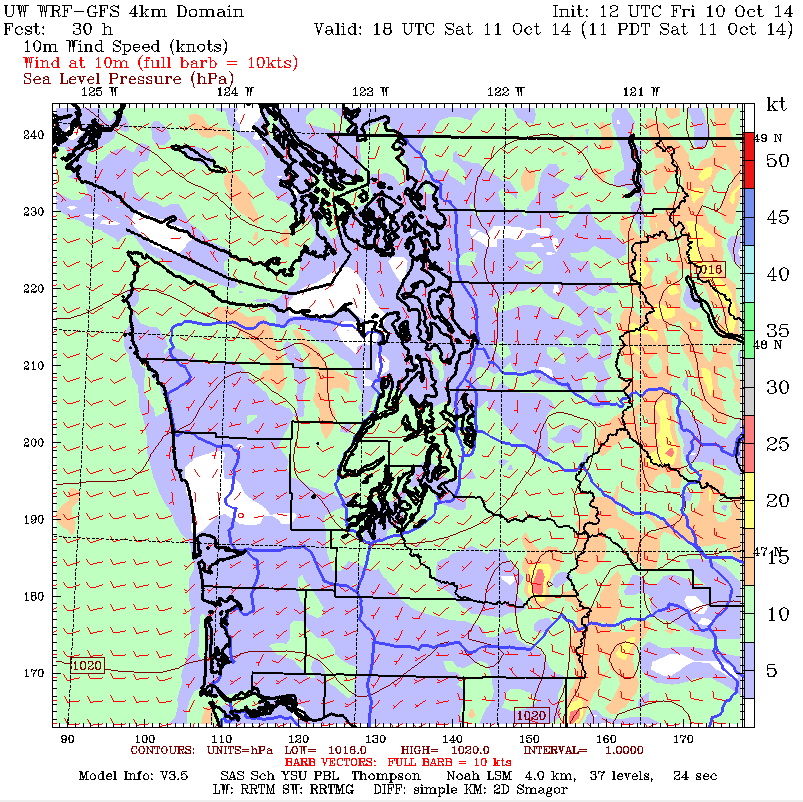
UW Wind model for 1100 Saturday.
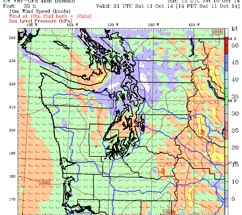
UW wind model 1400 Saturday.
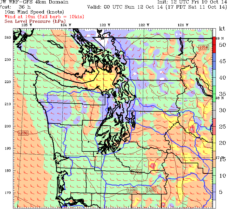
UW wind model 1700 Saturday.
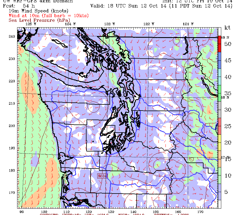
UW wind model 1100 Sunday.

UW wind model 1400 Sunday.
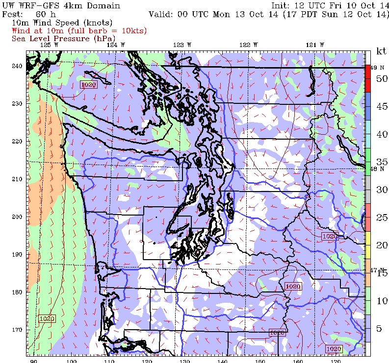
UW wind model 1700 Sunday.
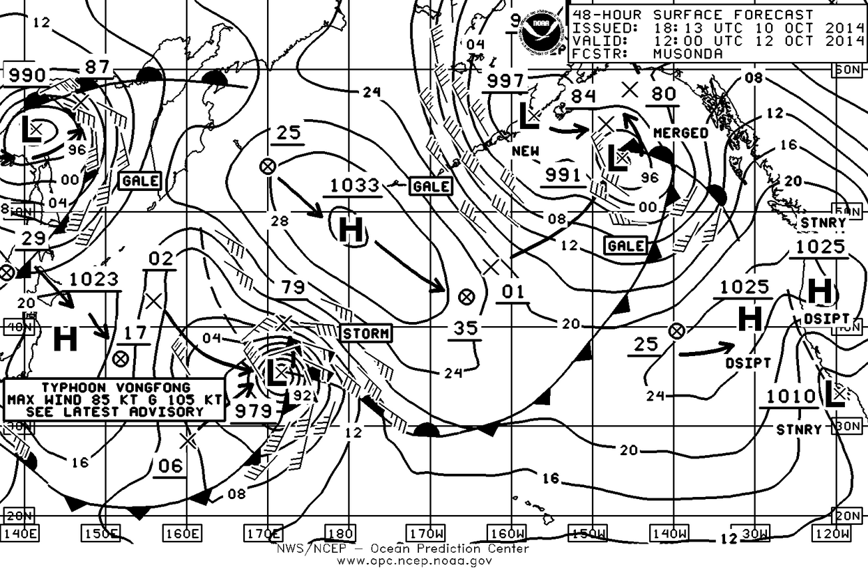
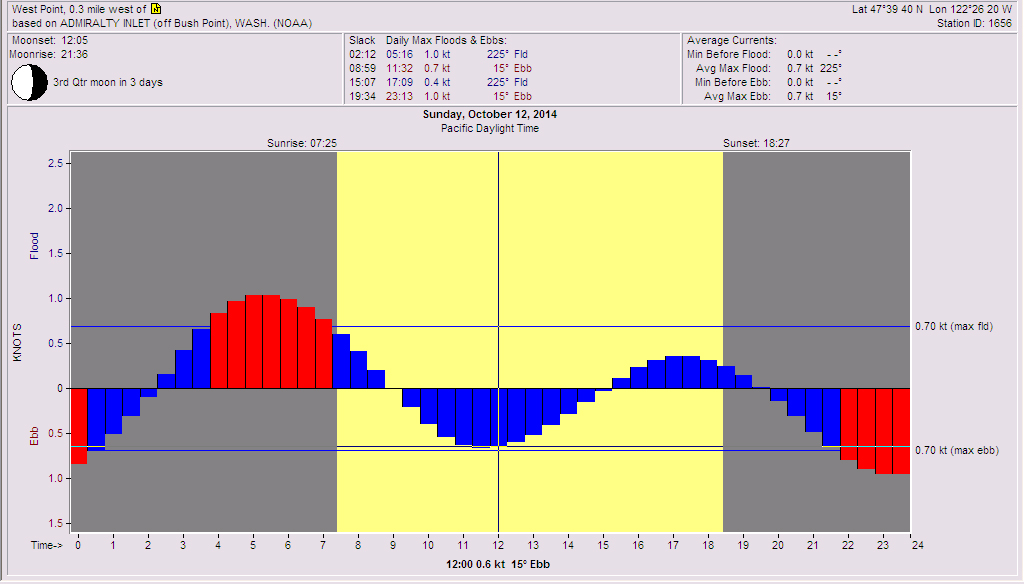
As I said, this weekend does look pretty good for the one of the last major sailing events of the year, Corinthian Yacht Clubs Puget Sound Sailing Championship. The usual format, two courses; one north of Shilshole for the big boats and one off of Shilshole for the slower rated boats. The Saturday surface forecast chart looks fairly benign as the ridge of high pressure that’s been protecting us from the early fall low pressure systems is clearly starting to break down. Even though there is little gradient over the Northwest showing at 0500 hrs, you’ll notice that offshore from Vancouver Island the gradient is compressing and this compression will be driven to the southeast by an approaching cold front associated with that 980 mb low. See the Sunday Chart. This will move south over the day on Saturday bringing a nice southwesterly flow over Puget Sound in the afternoon. The breeze in the morning will start out from south with a very localized southeasterly near shore especially at the mouth of the Ship Canal and just north of Meadow Point. The tides are such on Saturday that we’ll be starting near max ebb which is going to mean that coming off the line in clear air with a lane to the east will pay dividends. With the ebb it will probably help to overstand a little coming into the weather mark on port tack. This of course can be dangerous since the fleets will be tight and finding a hole in a parade of starboard tackers could drop you back very quickly. The other problem will be that as the day progresses the wind will clock to south-southwest and someone who bails early to port off the starting line and goes right out into the Sound is going to find that right hand shift and score. The crew on the rail needs to be watching for that and the boats on the North Course will want to have long eyes out to watch the racers on the South Course as they will get that shift first. (Read Ben Braden’s predictions to see who you should be watching.) As you leave the dock in the morning you’ll also want to warn your ace foredeck team that gybe sets may be in their future as the day goes on. Sometime after about 1500 hrs on Saturday the breeze will begin drop and there will be some huge right-hand puffs like 20°-30°degrees as the breeze will begin to come down from the north.
Saturday will also be the day to solidly cement yourself into first place in your fleet as Sunday is not going to be a day of consistent breeze. As you can see from the 48 hour surface chart once that weak front has moved on from Saturday, the gradient will ease as that 980 mb low in the Gulf Alaska retreats to the north and drags the gradient with it. Look for 10 knots from the south in the morning however that will gradually drop over the course of the day becoming light and shifty on Sunday afternoon.
Before you leave the house on Saturday and Sunday morning you’ll want to check Washington State Ferry Weather for current conditions on the Sound. Then check the weather at West Point: http://www.ndbc.noaa.gov/station_page.php?station=wpow1 and bring up Combined plot of Wind Speed, Gust, and Air Pressure to see what the trends are in barometric pressure and windspeed. Next go to the Western Washington Surface conditions http://www.atmos.washington.edu/cgi-bin/latest.cgi?sfcplots-wwa and check the gradient spread over the Northwest. Then make your own guess about conditions will be for the day!
Regardless, PSSC is always a pretty great event and the real rain won’t start until we’re on our way to work on Monday and the Monday morning commute will probably be one to avoid.
The other interesting weather feature to observe is on the 48 hour chart in the lower left hand corner and that is the 979 MB low pressure system and while it says Typhoon Vongfong, that Typhoon is actually over Japan and will become a post tropical storm as it moves northeasterly towards the Sakhalin Peninsula. I bring that up because it was the remnants of just such a storm that struck the Pacific Northwest on Oct 12th 1962 and caused the Columbus Day Storm that brought winds of over 100 knots to the region and did a lot of damage. The good news is that there is the 1033 mb high sliding into position to block that low pressure system, degrade it a bit, and maybe drive it north into colder water where it will weaken and become just another rainmaker headed into the Pacific Northwest.
Enjoy the weekend.

Tides for Saturday.
Tides for Sunday.