RTC (Round the County Race) is probably the best middle distance race there is in the Pacific Northwest and for a number of reasons. For one, it’s held a very challenging time of the year and this year will be particularly interesting as we already seeing the effects of a huge El Niño. The race is wildly popular with 114 paid entries spread over eight classes including a 13 boat IRC fleet, the biggest IRC turnout to date in the Northwest. There’s also a huge Canadian contingent that make the journey south and look for some of them to be on the podium.  It’s also held in one of the most beautiful areas there is and this time of the year it’s pretty much devoid of boaters even though it’s a great time to fish and crab. From what I’ve heard from Admiral Fish (Tony Floor) there are plenty of both around. Then the course itself may sound simple (Leave San Juan islands to port) but it is plenty challenging which is why you’ll find most of the northwest’s best sailors spread throughout the fleet. Lastly, the hospitality and Race Committee work is outstanding and the parties at every stop are legendary. What’s not to like?
The weather for this weekend’s RTC is going to be interesting, and challenging, to say the least.
Let’s start with what we know will be pretty close: Tides and currents. The course this year goes north from the Lydia Shoal Buoy in Rosario Strait with the first start around 0830 hours.
Rosario Strait Saturday
Slack 0906
Flood 1116 .9
Slack 1422
Ebb 1822 2.2
Alden Point Patos Island
Slack 0915
Flood 1050 .8
Slack 1437
Ebb 1729 2.5
Turn Point
Slack 0913
Flood 1218 .6
Slack 1516
Ebb 1820 1.7
This basically says the fleet will have a flood tide moving them north to Patos Island and then the big boats will have to fight a small flood until 1400-1600 hours after which the slower boats will have the ebb to help them down to the finish.
It’s when we start looking at the weather that things will get interesting. Usually as time to start gets closer the models tend to converge, not so much this year. For the delivery up to the Islands on Friday it will be a downwind ride in up to 25 knots of pre-frontal southeasterly. Should be a quick trip. Then as the front comes through early on Saturday there could be gusts to 30+ in the Islands. By the time we get around to starting mid-morning on Saturday, the breeze will start to drop and clock to the southwest. Since this front is weakening as it comes onshore, the models are decidedly different.
One scenario has the southwesterly holding and getting most of the fleet around pretty quickly. Running this forecast model with the polars for the RP-55 Crossfire has us finishing around 1245 Saturday afternoon.
The other scenario has a post frontal northwesterly coming down the Straits of Georgia and creating a convergence zone over the north end of the San Juan’s with very light (less than 5 knots) wind from the southeast and northwest. Once you get through the zone you could have a nice 12-15 knot northerly with a spinnaker run to the finish at Roche. As I said, very different models.
This will make life very challenging for the navigators so it will pay to know where you are on the course and don’t get too far from the rhumb line. 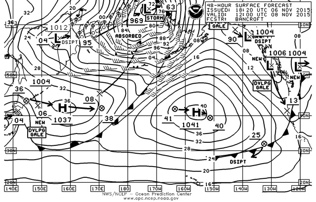 Watch your cog and sog when it gets light and track where the smart guys are going in your fleet. Above all else, be safe, run the jacklines for tethers and make sure everyone is in life jackets and safety harnesses, before you leave the dock.
Sunday looks equally challenging especially for the slower rated boats as it looks like we’ll have a post-frontal southwesterly for the start off of San Juan Island, making for a fast reach to the Salmon Bank Buoy. Then as you look at that 48 hour surface forecast chart you’ll notice that not only is the front dissipating, there is a new, very weak(1006 mb) low pressure system forming off the coast . By mid day on Sunday this will bring a pre-frontal south easterly breeze to the race course. The early boats to Davidson Rock will benefit by getting the kite up and running to the finish before the breeze drops and the big ebb of the day gets rolling.
Colville Island Sunday
Slack 1019
Flood 1213 .9
Slack 1536
Ebb 1910 2.9
Once again it will pay to know where you are on the race course and what the shortest course is to sail. As you hit the ebb tide coming out of Rosario Strait, you will need to play the backeddies along the west side of the Strait and stay out of the worst of the ebb.
As always, read the Sailing Instructions very carefully and note that you must record your time at the mid course finish points and email it to the Race Committee. You also need to hail the Race Committee before finishing and note the co-ordinates of the finish line for Sunday and pre-plan this approach carefully.
Have a great race and we’ll see you up there.
Ed. Note: Bruce will be navigating Crossfire.