


While last week’s Blakely Rock Race was interesting, this weekend looks to be a typical (if there is such a thing as typical in Putrid Sound) CYC Scatchet Head Race in March: rainy, windy, wet and cold. The good news is not too windy and not freezing cold. Just dress accordingly.
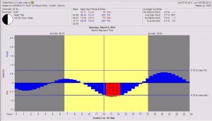
Tides at West Point
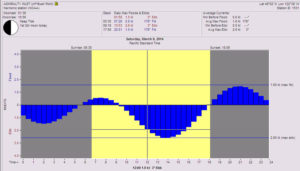
Tides for Admiralty Inlet
Wind and Tide
The surface charts for tomorrow show a typical frontal formation with a warm front preceding a stronger cold front. Remember frontal mantra for our area; warm fronts always precede cold fronts and cold fronts always move faster than warm fronts. When cold fronts run over warm fronts you have an occluded front. This formation will be bringing us rain and increasing breeze as the day goes along. Notice on the 0400 hrs chart that the cold front is well off the coast and by 1600 hrs (the 48hr forecast) that the front is right over Tatoosh Island, right where it says GALE. This is what will keep the wind from the south all day. Remember that as fronts approach the coast and encounter their first land mass that the speed of the front will change. You need to keep a visual watch in addition to tracking the changing barometric pressure. As the front approaches the pressure will be dropping as will the cloud ceiling. You will notice in the forecast table from PredictWind that rain should be developing over the course by around late morning. The other consistent feature to notice in both the PredictWind Model and the UofW MM5 Model is that wind will build as you get closer to Scatchet Head and will build as the day goes on. The wind will stay generally from the south all day and, so the next key will be the tide.
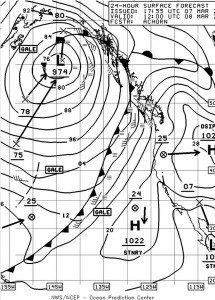
Surface Forecast 0400
This year we will have the big ebb of the day as the dominant tide for the entire race. The ebb will probably start 10-15 minutes earlier than predicted and will probably last 15-25 minutes longer because of the freshwater runoff coming out of the Ship Canal and the Duwamish, and the persistent breezy southerly we’ve had all week which causes a wind generated surface current with the less dense freshwater sitting on top of the denser saltwater of the Sound. All you had to do was see Elliott Bay this morning with its very muddy surface to realize there is a lot freshwater coming into the Sound. At the Scatchet Head mark you can expect the current to be running almost due west across the face of the bluff, over the Possession Bar.
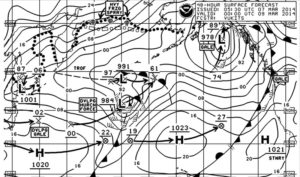
Surface Forecast 1600
In light air the current velocity can double in the last ½ to ¼ mile to the mark which in light air can make the rounding interesting if you haven’t put enough in the bank. This year with the anticipated breeze, it shouldn’t be an issue however you still need to be aware of it as the velocity at the mark will probably be in the 1 to 2-knot range. Max ebb at the mark will be between 1300-1400hrs. Make sure the COG/SOG features are cranked up on your instruments.
Tactics
With the wind staying fairly steady out of the south you will need to anticipate it building as you sail north. Forecasts indicate it could be in the 15-20-knot range however don’t be surprised if there’s slightly more. Breeze in the starting area will probably be in the 10-knot range so depending on the boat one thing you can do is start with the sail you’ll use coming back from the mark, which at this point looks like a #3. The less time you have folks tromping around in the bow, the faster you will go on the run. If however your particular boat just dies with a #3 in 10-knots of wind, stay with what works for you. Maneuvering with the three in a downwind start gives you great visibility however you’re just not as fast so you will need to anticipate that.


The run itself will probably be pretty much a rhumbline affair with maybe slightly more breeze to the west of rhumb. Remember also that the increasing breeze will be filling from the west. Keep the handbearing compass handy and keep track of anyone who gybes off the start and goes hard to the west. North of Jefferson Head the ebb will be slightly (.2 knot) stronger on the west side of the Possession Bar so sailing the extra distance to get over there may not be worthwhile.
Once you’ve rounded the mark (to port) comes the big decision of the day: go west young man or hoof it back to the east. In the past, in a southerly, sometimes it has paid to go west IF, and that’s a big if, you can escape the ebb and pick up the start of the flood. It’s also slightly shorter to sail that side depending on the number of tacks you do. This year however it looks better to go back down the east side for a couple of reasons. The first is that if you tack to starboard shortly after rounding you’ll be sailing into the ebb coming out of Possession Sound which maybe slow to begin with however as you get to the east you’ll begin to find that branch of the ebb that flows south out of Possession Sound. That ebb can run as far south as the Edmonds Marina. You’ll notice this effect when someone who has rounded ahead of you and tacked to the east starts lifting up above your course. It’s not really a lift, he just got into that current sooner. As you get closer to the east shore you will probably get knocked slightly as there is a topographically forced shift to the southeast next to the beach. Once you tack back to port the water should be smoother and the puffs off the beach will be lifts. Watch your COG/SOG and when you get headed, you’ve fallen off the wheel so tack back into the beach. This will be the rule all the way back to the finish just remember that there are some shallow areas south of the Edmonds Marina and south of the oil docks.
Another item to keep track off is into which groove you hoist the headsail. If you’re a little rusty on changes, hoist the sail into the starboard groove so when you do a change you’ll be on port tack headed away from the beach. That way since it always takes longer to get the sail up you’re not in danger of sailing into the beach in the highly unlikely scenario that all doesn’t go as planned.


I mention this because just as the breeze built going north, it’s probably going to drop as you head south. Those who sail aggressively and make the headsail changes when they should are the ones who will do the best. Just plan for it, talk it through and execute with purpose.
The other reason to go east this year is that if you go west you will have to cross the Sound in the big ebb of the day twice and that will not be fast.
Lastly, be conscious of the location of the finish so you don’t overstand if the visibility is low because of the rain and mist.
Morning of the day of the race.
Before you leave the house, check the Washington State Ferry weather on the Edmonds-Kingston run. http://i90.atmos.washington.edu/ferry/Ferryjs/mainframe1.htm
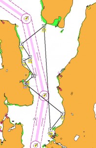
Possible Westerly route for 35-footer by Nobeltec
Check the pressure gradient from Bellingham south to Sand Point(NOAA Seattle) and south to Portland and southwest out to North Bend, Oregon. You can get this from the internet http://www.atmos.washington.edu/cgi-bin/latest.cgi?sfcplots-wwa or from VHF weather. A very basic rule of thumb is one millibar from Portland to Bellingham means 10knots, two millibars means 15-20-knots, and if the gradient from NB to Sand Point is 2 millibars or more the shift will be to the southwest.
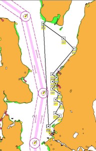
Possible easterly route for 35-footer created in Nobeltec.
You should also go to the National Weather Service-Seattle site http://www.wrh.noaa.gov/sew/, scroll down and click on the Langley Hill Doppler radar picture to see where the front is currently located. You can then go to the left column and click on the Loop under long range images to see how fast the front is moving.
Needless to say, if you’re racing you’re going to want this information anyway and from the moment you get to the boat you’ll probably want to write it down so can track the changes over the course of the day.
Good luck, be safe, and have a great race.
And don’t forget to move your clocks forward one hour on Saturday night. That is such a great feeling because it means evening racing can’t be far away!
2 comments
Many thanks for “Bruce’s Weather Brief: Scatchet Head 2014.” It is an absolutely wonder read. Is it evil to hope that none of my competitors read it?
Fortunately, and I’m sure Bruce would agree, even a good weather analysis will get you only so far around here. A similar question, is it evil for me to hope that the folk who read this do better than the folk who don’t?