


the strange dimples and knobs of the ice. This was no
ordinary ice cube; it was glacier ice.
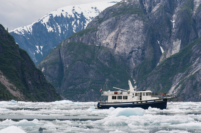
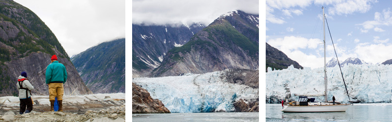
 We arrived that afternoon at No Name Cove (aka Tracy Arm Cove) in Holkham Bay, Southeast Alaska, ready to see our first tidewater glacier the next morning. To our delight, chunks of ice dotted the bay and we quickly snagged one for our icebox. Now, as I admired the sparkles, I realized with awe that I was looking at ice formed some 300 years ago, prior to both the American Revolutionary War and the Industrial Revolution.
Since that first cruise to SE Alaska, my husband Steve and I have made five more trips in our Annapolis 44 sloop, Osprey. Glaciers have been highlights of each trip. Their blue and white ramparts towering over our boat awe us and the roar of calving ice gets our adrenaline pumping.
Southeast Alaska’s tidewater glaciers run in an arc starting at Le Conte Glacier near the mouth of the Stikine River, continue north up the continental side of the archipelago, and then west to Glacier Bay. This distribution makes it easy to visit one or more glaciers on a cruise to SE Alaska’s main tourist destinations. It also makes possible a glacier safari – a voyage that will let you see almost all SE Alaska’s tidewater glaciers plus the region’s icefields, mountain glaciers, and evidence of past glaciation.
GLACIER DETAIL
JOHNS HOPKINS GLACIER
Nearest Anchorage: Reid Inlet, 13 nm
Glacier Status: Advancing/ thickening due to increased snow at higher altitudes.
Notes: Only advancing tidewater glacier in SE Alaska. Johns Hopkins Inlet closed to cruise ships 5/1-8/31. Closed to all vessels 5/1-6/30 due to critical seal habitat.
A glacier safari, like any cruise to SE Alaska, requires that you and your boat be prepared. Approaching an active glacier requires navigational skill and an understanding of how glaciers and the icebergs spawn move and change. Well-maintained machinery, enough anchor rode for depths of 100’ or more, and a spare propeller are all critical. Paper charts that show the contour lines of land and glaciers are also useful.
Your glacier safari will fall naturally into two segments with opportunities to restock in Juneau in between: the Frederick Sound-Stephens Passage area from Petersburg to Juneau and the voyage from Juneau out from Icy Strait to Glacier Bay. Either segment is ideal for having guests onboard. While in Juneau, you can take a land trip to the Mendenhall Glacier with its interpretive center.
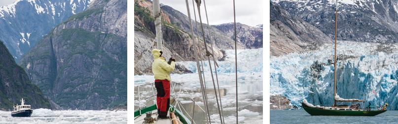
As you leave Petersburg heading north and enter Frederick Sound, the vista grows wider and the mountains steeper and closer to the water. You are in glacier territory. From here you can go either southeast to the Le Conte Glacier or northwest to Baird Glacier in Thomas Bay. Most boaters will choose to make Baird Glacier their first glacier. The narrow, current-swept entrance to Le Conte Glacier is clogged with ice and boulders and is dangerous.
Baird Glacier, Thomas Bay: Baird Glacier enters Thomas Bay between two bold granite headlands. Its main attraction is an outwash plain formed by river sediment flowing under the glacier. It’s a botanist’s playground with dwarf magenta fireweed, yellow lichens, and fields of blue lupines. Arctic terns wheel and call overhead, and the chill wind from the glacier whistles across the plain.
To reach the outwash plain, anchor in Scenery Cove on the east side of Thomas Bay and take your dinghy across. Find a nook among the river cobbles and pull the dinghy above the tide. Be sure to take a portable VHF radio. If you get into trouble, it could be days before other boaters visit the plain.
South Sawyer, Sawyer: Holkham Bay in Stephens Passage offers two classic fjords with three tidewater glaciers within the boundaries of the Tracy Arm-Fords Terror Wilderness Area. Tracy Arm, the more northern of the two arms, is home to Sawyer and South Sawyer Glaciers, while Endicott Arm hosts Dawes Glacier. All three glaciers are retreating. Sawyer Glacier grounded (meaning that it retreated to where none of it floats independently of the seafloor) in 2017, but the other two are still actively calving.
GLACIER DETAIL
DAWES GLACIER
Nearest Anchorage: Fords Terror outer cove 14 nm; No Name Cove, 32 nm; Woods Spit, 29 nm.
Glacier Status: Retreating. Very blue ice. Active calving.
Notes: Domes and u-shaped valleys from past glaciation. Seal pupping habitat.
Entering Holkham Bay is magical. Large blue and white icebergs sit on the terminal moraines that mark the entrances to Tracy and Endicott Arms, while steep mountains shrouded in mist hover above. Eagles are everywhere, perching on ice or diving for fish. Seals and whales frolic among the ice.
Tracy Arm Cove is near the entrance and provides a scenic and secure base from which to approach Sawyer and South Sawyer glaciers. Ice conditions can change from day to day, and boats returning from trips to the glaciers can give you updates on conditions up the inlet.
From the anchorage, it’s 21 nautical miles to the turnoff to South Sawyer Glacier and another several miles north to Sawyer Glacier. Even fast powerboats will take a whole day getting there and back when the ice is thick.
Traveling up Tracy Arm is like taking a boat trip up Yosemite Valley with domes, half-domes, U-shaped valleys, and sheer rock walls striated by past glaciation. Calving from South Sawyer Glacier can be so extensive that boats may not be able to get close. If so, continue north to Sawyer Glacier. Sometimes called North Sawyer, Sawyer Glacier lacks the drama of South Sawyer, but its blue and white ramparts and newly revealed red rocks make for great scenery. As you travel toward the glacier, keep your eye on your chart plotter, which will show the extent of the glacier’s retreat in the image of your boat’s icon traveling across the displayed glacier. Your depth sounder, however, will show several hundred feet of water.
If the approach to South Sawyer is partially clear, work your way through the ice as far as you can, turn off the engine, and drift. You’ll hear the boom of calving and the snap, crackle, and pop of melting ice all around you. It’s like floating in a giant daiquiri or margarita.
Seals give birth and raise their pups on the ice in front of South Sawyer. It’s fun to watch them, but stay as far away as you can. If your boat’s movement separates a pup from its mother, they may not find each other again.
Dawes Glacier – Endicott Arm: The inlet runs 32 nautical miles to Dawes Glacier, requiring either a very long day or an anchorage in Fords Terror to break up the trip. Be cautious; ice can clog the approach and even work its way into Fords Terror. The journey is a feast of color as the dark green of spruce and hemlock gives way to the red rust of newly exposed bare rocks. Finally, you arrive at the base of the intense blue glacier.
In 1794, when Captain George Vancouver sailed through Icy Strait, Glacier Bay was a mere five-mile notch. By 1879, when John Muir explored the Bay, its glaciers had retreated 40 miles. Today you can travel 60 miles up the bay. Traveling north up Glacier Bay has been likened to sailing back in time. You start with the “present,” a forest of hemlock and spruce at the bay’s entrance. As you move north, the forests give way to low-lying bushes, which in turn give way to lichens and mosses until you reach the distant “past” — barren brown landscape with glaciers beyond. As tourists, we appreciate Glacier Bay for its glaciers, wildlife habitat, and scenery. But the U.S. Congress preserved Glacier Bay as a natural laboratory showing how glaciation and deglaciation change the landscape and biology. Active research is still underway.
Once in Glacier Bay, you can visit both the western inlets of Reid, Johns Hopkins and Tarr with their active calving glaciers and the eastern Muir Inlet that serves as an astonishing reminder of how much the landscape has changed.
Reid Inlet: Reid Inlet is the only place in SE Alaska where you can anchor in front of a tidewater glacier (Reid Glacier) and go ashore to touch it. A glacial moraine at the inlet’s entrance sports fields of flowers and a freshwater marshland that was a tide flat only ten years ago. The melting of heavy glaciers is causing the land to rise. This small inlet makes a good base from which to explore
Johns Hopkins Inlet: With three actively calving glaciers –Johns Hopkins, Lamplugh, and Gilman — you can spend a whole day watching glaciers. Because of its origin high in the mountains, and because of climate change, which increases precipitation which falls as snow at higher altitudes, Johns Hopkins Glacier is the only tidewater glacier in SE Alaska still advancing.
A glacier is a large mass of moving ice. Snow becomes a glacier when it becomes deep enough for its weight to cause it to recrystallize. Mountain glaciers form high in the mountains and move downhill like rivers of ice. Tidewater glaciers are mountain glaciers that terminate in the sea. That’s where things get exciting as seawater erodes the glacial face and the glacier starts calving.
Mountain and tidewater glaciers are always moving as new ice forms at the top and flows downhill like conveyor belts. If more snow falls at the top in the winter than melts in the summer, then a glacier advances. But if the ice melts before reaching the bottom, the glacier retreats. The conveyor belt still moves, but it’s now shorter.
Tidewater glaciers calve whether they are retreating or advancing. To tell which a glacier is doing, look at the land immediately down inlet. If there’s no vegetation, the glacier is retreating.
Tidewater glaciers have a natural cycle of retreating and advancing. As a glacier advances down a fjord, it pushes a pile of dirt ahead of it underwater. If a glacier retreats before reaching open water, it leaves the dirt behind in the form of a bar, called a terminal moraine. If instead, the glacier pushes the moraine into deeper water, the ice loses its support, collapses, and begins retreating. When a retreating glacier reaches land, a new moraine builds, and the process starts again.
But to this process, we can now add a new twist: thanks to climate change, ice now accumulates at a slower rate and a grounded glacier that would have advanced in the past, now keeps retreating uphill. According to the Glacier Bay National Park Fairweather Guide, ninety-five percent of Alaska’s glaciers are thinning, stagnating, or retreating.
Several smaller glaciers in the inlet no longer reach tidewater. As they shrink, they reveal a tectonic mélange of faults and varied rock types. To protect critical seal habitat, the Park Service closes Johns Hopkins Inlet to all vessels from May 1- June 30.
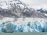
Tarr Inlet: As you approach Tarr Inlet, you’ll see the magnificent sweep of the Grand Pacific Glacier coming down from Canada. Up close the Grand Pacific morphs into a dark silent glacier, covered with dirt and rocks: the Darth Vader of glaciers. Kittiwakes hover in the mist off its face calling “mew, mew, mew.” Immediately west of the Grand Pacific Glacier, the blue ramparts of Margerie Glacier tower above the water.
Muir Inlet: Recently bared rocks appear to glow in the afternoon sun as you motor up Muir Inlet. The inlet is closed to motorized vessels north of 59° 2.7’N from June 1 to July 15, a restriction that leaves the once great Muir Glacier out of sight. Casement Glacier and Riggs Glacier are still visible. McBride Glacier has retreated around a corner, leaving a surreal landscape of icebergs adrift in a shallow lagoon.
Glaciers aren’t the only attraction of this spectacular park. You can see whales, sea otters, sea lions, brown and black bears, and herds of mountain goats.
After leaving Glacier Bay, swing by Taylor Bay at the southern tip of the Glacier Bay National Park and Preserve to see the 24-mile-long Brady Glacier. If you’re lucky and have clear weather, you may also enjoy a view of the Fairweather Range and the Brady Glacier from the outer dock at Elfin Cove in Cross Sound. The sight of this magnificent glacier glowing in the sunset, is a fitting end of an inspiring and thought-provoking glacier safari.
Permits are required to take your boat into Glacier Bay from June 1 through August 31. Forms are available at http://www.nps.gov/glba/planyourvisit/boat.htm. The National Park Service allows only 25 boats in the bay at a time, 13 by long notice permit (60 days ahead) and 12 by short notice (48 hours ahead). To increase your chance of getting a permit, submit your application at the earliest times allowed and remember the time difference when applying from out of state. Glacier Bay is large. Ask for the full seven days allowed.
Describing Tracy Arm, the US Coast Pilot® 8 Alaska advises, “Glaciers can be very active, and huge blocks of ice fall off their faces. These can generate waves …as high as 25’; however, a small boat can ride the waves safely if it keeps a few miles distance from the glacier face and avoids getting packed into the ice flow.” This is good advice for all glaciers in SE Alaska, although the National Park Service recommends a quarter-mile distance in Glacier Bay. As you approach a glacier, keep in mind it can calve from underwater, not just off the face. A giant block of ice once surprised us by shooting into the air from the base of Dawes Glacier in Endicott Arm.
Remember, you’re navigating through ice, not icebreaking. Glacier ice moves constantly, propelled by currents. The ice around you may ride deeper than your keel and may move in a different direction. Go slowly, watch for leads, and if necessary, stop and drift until the ice opens. The risk is not usually hull damage but propeller damage. The most dangerous time may not be when you are close to a glacier (unless you are too close) but when the distances between ice chunks is large enough to lure you into picking up speed.
Watch out for dark blue ice, which is denser, floats lower, and is almost invisible. In 2013, we struck one of these low-floating ice bergie bits head-on despite having two people on watch. As the boat rode over the ice and back down the other side with a thud and a splash, we heard the distinctive clunk of propeller hitting ice. We limped to a Juneau boatyard to change to our spare propeller.
Icebergs can float far from their source. Navigating among them in the fog can be spooky. Use your radar, go slowly, and keep a respectful distance. Icebergs can roll over suddenly when their undersides erode and they become unstable. It used to be popular to go onto icebergs in your swimsuit and have your picture taken: an extraordinarily foolish thing to do. Cruising among glaciers is exciting, challenging, awe-inspiring, and dangerous. Be safe.