


A hands-on introduction to currents,
tides, and chaos aboard.
 You couldn’t ask for a better fall morning in the Pacific Northwest. We left Edmonds for Victoria, British Columbia, riding a nice ebb current out through Admiralty Inlet. Puget Sound was glass. It was one of those rare moments where our massive inland sea was as placid as a small lake. The only thing disturbing the mirror-like surface was the wake and prop wash behind my friend Ron’s Tartan 33. We lounged in the cockpit, sipping coffee and listening to music. The ebb current helped us along as planned, adding 1-2 knots to our boat speed. Not that we were in a hurry. Some porpoises swam with us for a mile or so. As the sun rose higher, we peeled off layers as it became shorts and T-shirt weather.
As we motored past Bush Point on the west side of Whidbey Island, we began pushing through a small northerly swell, but the water remained mirror calm. I glanced at the GPS. We had picked up another knot of helping current. Speed is relative on boats, but for a sailboat under power, we were really moving.
Near the north end of Marrowstone Island, the swell grew, but we lazily rolled over each one, not even at risk of spilling our drinks. We were making great time, and the ebb was going to run for quite a while longer on what was a pretty big tidal exchange. With luck, we would have a helping current most of the way out to Victoria before the tides switched and the flood current began refilling Puget Sound. Given the typical area wind forecast of “variable to 5 knots,” we were glad for the help.
Around Point Wilson, the swells were steeper and quicker. We looked around for the container ship that had to have thrown a huge wake. Nothing. The horizon was clear.
Another glance at the GPS—10 knots. At least 3 knots of current running with us, I figured. The first wave came over the bow not long after that, and in seconds we were in it. The Point Wilson Rip.
The Salish Sea is a maze of channels, islands, deltas, and reefs. There is no single forecast that covers it, and there is no quick way to learn the nuances of its currents. If you drained the water from the Puget Sound, you would see huge canyons and constricted passes. Rock formations lurk just below the surface. Sandbars stretch out far into bays.
The underwater topography, in part, dictates how the water moves as the tides ebb and flow twice each day. Add the thousands of rivers and streams emptying into the Salish Sea and you get a complicated system of fast currents, back eddies, whirlpools, and overfalls that seem to come and go as quickly as we discover them. Being able to recognize and navigate these complicated currents is part of what sets Northwest boaters apart from the rest.
Lower Puget Sound has 1,300 miles of complicated shoreline, pinching and redirecting an average of 1.3 cubic miles of salt water on each tidal exchange, most of it running through Admiralty Inlet. Take a moment and look at a chart of Puget Sound. Go on, I’ll wait.
Imagine a flow of water heading north from somewhere between Seattle and Bainbridge Island. Notice the constrictions and side channels. Absent of other forces, that water is going to hit Whidbey Island and split off in two directions. One flow would head northwest toward Port Townsend, the other northeast toward Everett. Except there is a concurrent flow coming south out of Port Gardner, which joins the water coming from the south, creating a tide rip somewhere near the fertile salmon fishing grounds of Possession Point. Travel around the chart and trace where you think the water should flow with different currents. You quickly see the problem areas. It isn’t as simple as draining or filling a bathtub twice a day.
Learning to navigate and plan routes in the Puget Sound is as much an art form as it is a science. Current and tide tables can help give a general sense of where the water is moving and when, but only local knowledge, and a lot of it, can make you a seasoned sailor here.
Even complicated current tables can be off by several factors during rain storms or after a low-pressure system sweeps over the area. In some areas, currents defy all logic, sometimes running counter to the dominant ebb or flood cycle. Colvos Passage, for example, always flows to the north. Some areas never seem to experience any actual slack current between ebb and flood and still other areas never get any noticeable current at all.
Learning the currents pays huge dividends for any boater, but especially those in slower-moving tugs, trawlers, and sailboats. When your typical cruising speed is 7 knots, a 1-knot push or knock can make a big difference in your travel times and fuel economy. And knowing where water comes together with other water is hugely important.
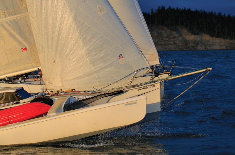
At this point, neither of us had heard of the Point Wilson Rip. We had each crossed the Straits of Juan de Fuca dozens of times over the years, but had never seen what stared us in the face that fall day.
Once we rounded Point Wilson, we saw a thick bank of fog to the west. Massive, steep waves stood straight up and came from three different directions. It looked like there were whitecaps on the horizon, but there wasn’t a breath of wind. The current, still behind us, started to grab the rudder and slide the stern out from under us, like a pickup truck losing traction.
We barreled headlong into steep waves, taking green water over the bow, and soaking everything in the cockpit. Our leisurely cruise was turning into a bit of an adventure.
We pounded into the waves and waves pounded into us. At one point, we took two waves at the same time, both from different directions. The ceramic mug I had been drinking from crashed onto the cockpit floor and shattered. Just as I was about to dash below to grab our PFDs, a wave tore the anchor from the pulpit, leaving it hanging from two feet of chain so it could bash into the hull.
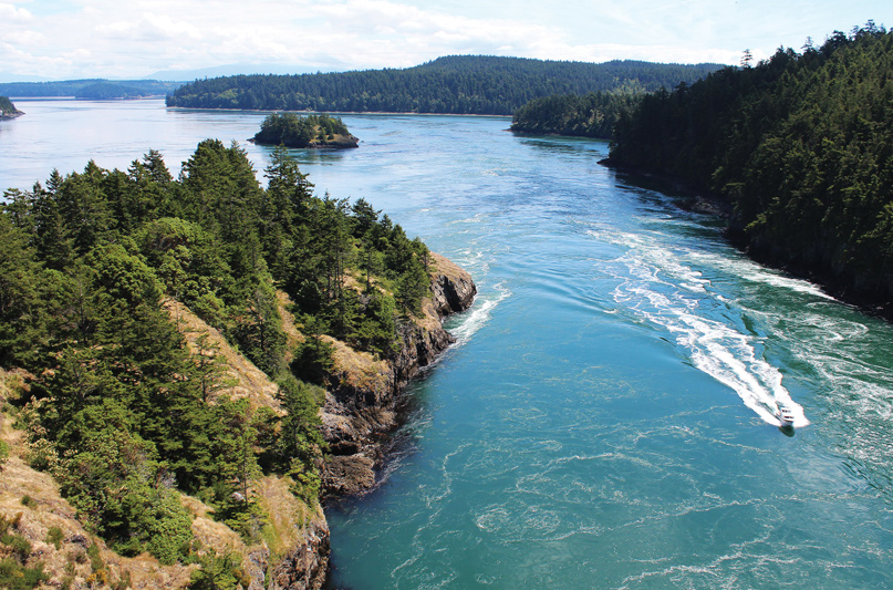
Fast currents and dramatic passes get a lot of attention in the guidebooks and other boating media. Spectators line up on the Deception Pass Bridge to watch boats navigate the swift, complicated currents that tear past the rock cliffs lining the pass. Boaters wait for hours to transit passes in British Columbia. Those passes and currents demand respect, but they are well known and oft-traveled. Generally speaking, if you aim for either side of the predicted slack current in someplace like Deception Pass, you will be fine.
Of course, if you mistime your approach by too much, you could be in for a wild ride downhill or a treacherous slog into the stream.
Timing is the tricky part. The trip from Seattle to Deception Pass on the east side of Whidbey Island is roughly 55 nautical miles. At 7 knots, this is just shy of an 8-hour trip. Add a couple hours of a 2-knot, helping ebb current and you are going to be early. However, you won’t have an ebb the whole way up the inside of the island, so you will, at some point, hit slack water and likely, a little current on the nose. Add some local anomalies like the unpredictable waters in the Skagit Delta at the north end of Camano Island and the chances of arriving at the pass on schedule are further reduced. With a maximum current of nearly 9 knots, missing your arrival window at Deception Pass can mean a long wait or a dangerous passage.
Based in Everett, we are often faced with tough decisions regarding currents and travel distance. On a southbound to Seattle, for example, the ebb current is strongest on the east side of the Sound, whereas you can catch a long stretch of smooth water from Point No Point south to Jefferson Head. Is it worth crossing all of the way over to the west side of the channel, adding 8 miles to the trip just to avoid pushing through a strong current? We also have to consider the fact that the ebb current out of Everett will push us south to Possession Point, but somewhere before Edmonds the ebb will be flowing north out toward Admiralty Inlet.
We have found that with our boat speed it is usually impossible to avoid fighting some currents along the way, but we’ve become adept at knowing which currents to fight and which ones to avoid.
With Ron at the helm fighting each heave and roll, it was up to me to make my way to the bow and wrestle the anchor back into the chocks. Waves crashed over me and lifted me off the deck. Cold water poured down my back. My favorite hat disappeared into the froth. I finally dragged the anchor into place and lashed it down with some industrial zip ties and made my way back to the cockpit.
We rolled so hard that the starboard rail went under. Then we pitched over a wave and took another soaking across the bow. It was a chaotic mess and the GPS said we were still moving at 10 knots. From inside the battle, it looked like this would be our fate all the way to Victoria. In our haste, we made a decision that in hindsight is one of the stupider ones either of has ever made as captain. We turned around.
Currents and tides aren’t the same thing, but they are related. In a system as complicated as Puget Sound, relying on a falling tide to equate with an ebb current is going to get you into trouble. It just doesn’t work that way. Every vessel should have a current prediction table and a current chart. A current prediction table is just like a tide table. It gives you current speeds in knots for specific stations at specific times. A current chart shows general current directions at various times related to slack.
I first discovered current charts when I was learning to scuba dive where slack water is by far the preferred time to be in the water. Studying a current chart illuminates the vagaries of the moving water, but even these charts are limited in their precision and detail.
They don’t show you, for example, that the ebb current flowing out of Admiralty Inlet is far stronger on the Port Townsend side than it is on the Whidbey Island side, a lesson I learned over many years of sailing the ‘Round Whidbey yacht race.
I’m not sure why we didn’t factor in the current when we turned, but Ron found the face of a wave that looked promising and swung us around, pointing the bow for the shelter of Port Townsend. It felt strange to seek shelter when there still wasn’t even as much as a breeze, but we were getting battered.
We turned and began what we thought would be a dash into town. Cold beers awaited us. We were initially happy with our changed plans. We could stay in Port Townsend for the weekend. It was a shorter trip home on Sunday. We could visit friends and scrounge around in the boatyard, if we could get there.
We turned and began what we thought would be a dash into town. Cold beers awaited us. We were initially happy with our changed plans. We could stay in Port Townsend for the weekend. It was a shorter trip home on Sunday. We could visit friends and scrounge around in the boatyard, if we could get there.
The current that had been pushing us out into the Straits was now fighting us. Instead of moving fast over crazy waves, we were barely moving. The GPS taunted us: 3 knots. For a few moments, I really didn’t think the rip was going to let us out.
Currents interact with every piece of the environment, including the weather. Opposing wind and current create short, steep wind waves. Flowing together, the waves flatten out. Where currents meet and form tide rips, the wind can churn up confusing, dangerous chop. We have been pinned to docks on a dropping tide, where the current running out of the marina sucked us against our fenders.
After long rainy spells, when the Puget Sound’s salinity is diluted, currents and tides can be exacerbated, especially near river mouths. Debris and deadheads get caught up in rips and whirlpools, just waiting for your hull to come cruising past. And sometimes, a distant weather event far beyond where you intend to be cruising can interact with a fast-moving current and absolutely ruin your day.
We limped into the Point Hudson Marina, tired and soaked. The boat was a mess. Not anticipating anything but smooth water, we hadn’t locked things down, and the cabin was a yard sale of clothes and provisions. The bow of the boat was battered from its fight with the anchor. We were simply not prepared for what hit us.
The Point Wilson Rip forms when a strong ebb current meets a strong westerly wind, which usually only blows in the evenings in the summer months. In the relatively shallow water north of the Point Wilson lighthouse, the rip is given all the fuel it needs. What Ron and I didn’t pay attention to was the overnight weather in the central Straits of Juan de Fuca. A near gale had been blowing most of the night, creating big swells that ran down the Straits with the overnight flood tide. Those swells, absent of anything to stop them, rolled right into the eastern Straits, where they were met by the morning’s strong ebb current.
Our calculations were right: the ebb carried us swiftly out of Admiralty Inlet. But we did not take into account the atmospheric conditions that would set up the obscure Point Wilson Rip. In the months after our hands-on education I asked every sailor I knew about the rip. A few had heard of it. One friend knew of a sailor who lost the dinghy he was towing through it. But with the exception of a short sidebar in a cruising guide, there was little to no mention of this phenomenon anywhere in my books or online. These days, you can find some discussion of it online and even a few videos of boats going through it, but in all my years sailing these waters, no one warned me of it.
It takes a lifetime of sailing these waters to learn its many facets. If you have been cruising without giving much thought to currents and how they affect your speed, comfort, and fuel economy, it can be a fun and challenging addition to your piloting. I treat navigation and route planning much the same way I do when driving my girlfriend’s hybrid car around town: looking for the sweet spot where speed and fuel economy are at their peak. The GPS tracks on my chartplotter show me wandering around, testing one side or the other of a tide rip or trying different depths.
A good place to start is simply studying charts. Zoom out. Look for places where the shoreline intrudes on what would otherwise be a smooth flow of water. Look for places where small bodies of water empty into larger ones. Look at passes between islands and try to predict where ebb and flood currents will meet.