
Jeffrey Linn created a fascinating map that shows where Puget Sound shorelines might be if the polar icecaps melted for another 5,000 years and raised the water 240′. As Linn puts it, don’t chose your next apartment based on this. My house appears to be just high enough to be dry and have a great view of “Green Lagoon.” Maybe a distant relative will end up with the dock in front of their house that I’ve always dreamed of. Original post at The WholeU here. A page dedicated to this exercise with more detailed maps is here. You can even buy a poster at http://www.zazzle.com/fremap.
By Jeffrey Linn
If there’s one thing I learned as a Boy Scout, it’s that you should pitch your tent on high ground.
I’ve lived in a few places in Seattle, most of which have been on hills or ridges. One was in a valley, just a few hundred feet from the Lake Washington Ship Canal. In every place, I always had the awareness of whether or not I was on high ground. I always felt comfortable with my site when I lived on a hill, but every once in a while I would have a vague uneasiness about living on lower ground near the Ship Canal. My Boy Scout lesson was learned a bit too well.
With this particular neurosis, it made sense that I’d think about the effects of sea level rise on the city and neighborhoods around me. It was something I wondered about occasionally, looking at topographical maps to see how high, in relation to future shore lines, was my house, my office, my friends’ and relatives’ houses. I’d seen a few maps showing the impact of 10 feet of rise in Seattle—certainly significant, but they didn’t show the full result of hundreds or even thousands of years of ice melt.
I was finally inspired to do this project by the San Francisco blogger Burrito Justice, who posts about, among other things, San Francisco history, geography, and burritos. He created a map of San Francisco as it would be with extreme sea level rise. I shamelessly stole his playful approach to mapping future geography, creating names for the new islands and landforms of Seattle that would result from hundreds of feet of inundation. This map is based on real-world information—I created the Seattle sea levels from publicly-available LiDAR data, rendering the rise of the seas in 10-foot increments for the animation, starting at the current shoreline, and ending with the 240-foot level. The Islands of Seattle poster was rendered at 240 feet of rise, which is roughly what would happen if all the world’s ice sheets melted.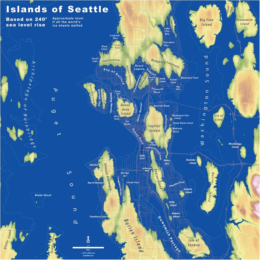
I don’t know how long it would take for this to happen. One estimate says roughly 5,000 years. If this is accurate, then our descendants living with this level of sea rise would look back on our time in the same way that we might look back on the Early Dynastic Period of Egypt. The time of the pharaohs would be closer to us than the time of the Seattle Archipelago. So, although we should all be very concerned about the effects of climate change, including the resulting sea rise, don’t base your next apartment rental decision on this map.
But you should always pitch your tent on high ground.
Jeffrey Linn is a planner specializing in urban design, sustainable transportation, and geospatial analysis. A dedicated urbanist, walker, and cyclist, Jeffrey is an advocate and designer for Safe Routes to School and Seattle Neighborhood Greenways. He currently works as a Campus Planner at the University of Washington Office of the University Architect. He has a BA in Geography from San Francisco State University and an MLA in Landscape Architecture from the University of Washington.
The Islands of Seattle mapping project is in no way associated with Jeffrey’s role as a planner at the University of Washington.
These maps can also be found at http://spatialities.com/islandsofseattle/