Absolutely one of our favorite regattas and one we don’t miss. Since it’s always held for a great cause I think the wind gods tend to smile on this event more often than not. This year the proceeds from the BRBR go to Sail Sand Point so go to the Sloop and spend some money and help this great organization out.
Tides, Wind, and Tactics
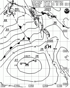
Surface Winds 0500 hrs
The wind will almost certainly be from the south-southwest at the start as a weakening front moves onshore providing us with some rain and hopefully some wind. Both models show wind with the PredictWind models showing about five more knots of wind than the MM5 models. As you can see from the Surface Forecast Chart, the front will remain offshore with the pressure gradient tightening over the course of the day which will probably give us more wind later in the day.
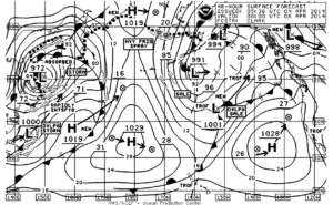
Surface winds 1700 hrs
The race will start at 1100 hrs which means that with the reverse start, the small boats and NFS boats will start first and sail right into max ebb which is at 1115-1130 hrs and should measure .6 knot at West Point. Considering the amount of rain we will have had over the last 24 hours and the fact that it has been blowing from the south for the last 48 hours averaging probably 8-12 knots expect the ebb to be running harder than that by .2 to .3 knot and lasting as much as 30-45 minutes past the advertised slack at 1517 hrs. This will dictate that after the start it will be the classic beat feet up the Shilshole Breakwater in what should be a very localized south-southeasterly. If you get forced out of the starboard tack parade to the beach, hitch to port just long enough to find a clear lane back into the beach.Avoid the restricted zone delineated by the Sailing Instructions and don’t come back into the beach sailing on starboard directly into the outfall from the Ship Canal.
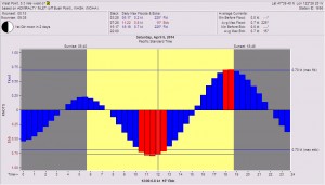
Tides at West Point
Work your way under West Point and remember that sand bar at West Point now has a shallow bump north of the line from the lighthouse to the West Point Buoy and remember that it is a falling tide so parking in the sand can be very expensive when it comes to time lost. The safe way to cross the shallow spot, depending upon the draft of your vessel, is to be about ½ way to ¾ of the way off the beach to the buoy. Then don’t hitch back into Elliott Bay once you clear the Point because as we saw on the Three Tree Point race, the tide ebbs harder along that shore because of the outfall from the Duwamish with the freshwater staying on top of the saltwater and there being a wind driven surface current.


From West Point hold on port tack and get to the Bainbridge shore. Remember also that with the reverse start you’ll be sailing into the slower boats which means you really have to focus on keeping your air clear. If you find yourself sailing slower than targets or sailing inexplicably lower than your fleet, you may be in dirty air. You’ll be progressively headed as you go across the Sound. Get far enough across to get out of the major part of the ebb before you hitch back to starboard and go towards the Rock. If you can, take advantage of the ebb out of Eagle Harbor which flows to the SSE almost ½ way to Blakely Rock.
It’s going to be the leg from Blakely Rock back to Meadow Point that will be interesting because you’ll be fighting to keep your air clear from the big boats trying to sail over the top of you. It may pay to take a short gybe to port to stay in what should be more air to the west of the rhumbline.


Since the leeward mark is Meadow Point, you are not going to want to stray too far from the rhumb line course. The rhumb line will keep you close to West Point and the ebb will keep you out in the tide on starboard gybe. After you get past West Point you are really going to have to start thinking tactically about the leg from Meadow Point back to the finish for a couple of reasons. The first is that the fleet will be compressing at Meadow Point and the starboard tack into the beach won’t last very long and will get shallow in a hurry so the spinnaker drop at Meadow Point better be perfect. You want to make sure you are clear to tack cleanly to port to get away from the beach. Then you’ll have to find a lane of clear air up to the finish. The other problem is that we will be sailing to the north on starboard while the dinghy fleets from CYC will be sailing to the south on starboard and they will be the leeward boat so anticipate this situation.
Before you leave the house you’ll want to check the weather at West Point for wind direction, and wind strength and the trend in the barometer which should be dropping. Next you’ll want to check Washington State Ferry weather on the Bainbridge Island and Edmonds-Kingston run. When you get to the boat, crank up the VHF to KHB-60 NOAA Weather radio and log the pressure readings for Forks, Bellingham, Seattle, Portland, Astoria,. North Bend, and Wenatchee. Those get updated every three hours and it will help you get a feel for when the northerly will fill down the Sound.
Then above all else, HAVE FUN!