
to the bottom of that bridge?
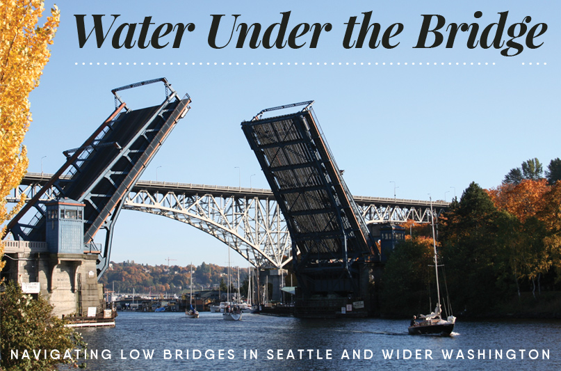
When traveling into the Seattle-area lakes eastward or expanding your horizons westward out to the Salish Sea, knowing our waterways, including the opening of bridges, is vital. Is your knowledge enough to make your transit skillful and timely? Can you slip under that bridge if the tide is low?
Decades ago, my Beneteau sailboat’s mast was scratched on the lower reaches of a bridge, a memory I’d almost forgotten. Writing this article brought back that dreadful moment. We all make a mistake occasionally, and attention to detail can go a long way towards keeping you and your family and friends safe with the boat intact. My mast survived; my pride had more damage. Other boaters have had different outcomes.
There are many bridges in Washington, with more than a dozen moveable bridges in the Puget Sound area. Our federal laws state that marine traffic has right of way over vehicular traffic. With the increase of vehicle congestion, especially around Seattle, there’s currently a compromise that places times and limits on openings during peak traffic. Size does matter and the big vessels (over 1,000 gross tons) still receive a timely opening upon request. Big or small, each boat captain must possess patience and respect, essential qualities in navigating these urban waterways. Listed below are crucial knowledge and equipment that will also help you get to where you want to go without injury or damage.
Five Easy Pieces of Knowlege:
- Understand how to be patient and respectful
- Total height of your vessel
- Clearance height of the bridge
- Factors of water level such as tides and lake levels
- How to communicate for opening the bridge
Five things to have on hand:
- Current charts or equivalent such as United States Coastal Pilot
- Current tide tables if venturing towards or from salt water
- Working horn or sound device including a spare or backup
- VHF radio capable of being tuned to channel 13
- Ample amounts of patience and respect
South Lake Washington to Shilshole
Let’s first plan our move for a hypothetical Super-Guppy (Guppy), a vessel equipped with a mast that lowers. The height with mast in the up-position is known to be 41’ 6” and when lowered, the height is 28’ 2”. Leaving from South Lake Washington, we wish to arrive in her new slip at Shilshole Bay Marina. The timing needs to happen October 1, per moorage agreements. Studying the charts, there appear to be many choices:
Choice #1 is what side of Mercer Island shall we travel – the shorter distance requires lowering the mast, the longer distance has plenty of clearance. Where would you find that information? Charts have vast amounts of information; essentially novels displayed graphically. You know the I-90 Bridge has boat traffic traveling under the west and east ends, but you don’t know if Guppy slips under. Reviewing the chart, at each end area you’ll find East Fixed Span… VERT CL (Vertical Clearance) 29’ and West Fixed Span… VERT CL 29’. OK, with mast down you’re good to go that direction.
Choice #2 is to travel the longer, counter-clockwise distance past Newport Shores and not have to lower mast by going under the I-90 East Channel Bridge with VERT CL 72’. Before finalizing to keep that mast up, further study the other bridges along the route. Continuing your planning northwards, the SR 520 bridge looms and again, you can find multiple ends to pass under; the East Fixed Span… VERT CL 57’ and the West Fixed Span… 44’. This shows you pass under at either place, mast up or down. After the 520 bridge, the course turns to the west and the next bridge along the path is the Montlake Bridge with a VERT CL 32’ (48’ at center).
Noting these heights, either you’re near the center or the mast must be tilted down. Since your crew today is limited and the lowering of mast process is new to them, the Guppy is leaning towards leaving the mast up and transiting towards the middle of the channel at the bridge.
Looking farther west, there’s the University Bridge and a similar VERT CL 30’ (45’ at center), therefore staying on northern side of the bridge’s center will allow the Guppy to pass under. As a good captain should understand, your fantastic crew deserves a stop at one of the several restaurants with docks in Lake Union (future article to be written).
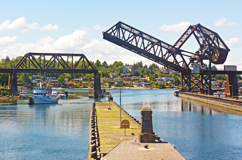
After rewarding your crew, the lowest of the bridges is next on the northwestern end of Lake Union—the Fremont Bridge—and studying the charts, a VERT CL 14’ (31’ FOR CENTERAL 38’) is listed. Again, by lowering the mast, Guppy fits. But with mast up? No! Guess you should consider opening that bridge. Along the transit, various signs posted on the bridges structure list horn sounds and a phone number for late night transiting (see picture below).
The US Coast Guard has requested all pleasure craft to use sound signal from 0700 hours to dusk and refrain from using VHF channel 13. Additionally, read and review Opening the Bridge (under the Where to Look sidebar at bottom of page) where several links are provided, which outlines the elements of opening times and standard procedures.
Now back to our scenario. You’ve arrived just after 1430 hours thanks to your extended lunch stop. To get the attention of the bridge tender as a pleasure vessel, blow your sound device (one prolonged blast and one short blast). The bridge tender echoes back the same sound (yipee!) and the bridge shall shortly open.
If you hear four short blasts, the bridge tender has reviewed traffic congestion along with positions of nearby vessels and decided not to open the bridge at this time. Okay, remember that essential quality of patience. It’s important to allow other vessels to safely pass as you wait; the bridge tender has a stellar view of you and most of the world – remember patience! Instead, enjoy the appetizers provided by your crew and marvel at the clouds or people watch.
Shortly you’ll hear the sounds, one prolonged and one short blasts, signaling the opening will soon start. Watch for the closing gates and vehicular traffic on the bridge to clear, listen to hear the locking pins release, and stand by to proceed. Five bridges done and two to go.
The Ballard Bridge is the last remaining bridge in freshwater and lists its clearance as VERT CL 29’ (46’ at center). From the previous experiences, you know the heights are good. Ahhhh – the Locks – so unique. Feel free to reference the Northwest Yachting’s Unlocking the Locks feature (March, 2017) on navigating them in greater detail.
While in the Locks, look west and spy the next bridge; Burlington Northern Railroad (or Railroad Bridge #4). Is it up or down? Will it stay up? If down, does the Guppy skate under? In simple terms, do your homework and know the tide! The charts listing is VERT CL 43’ MHW. MHW means Mean High Water. So, it’s science time, back to school; thank goodness NOAA has been on this case and provides great resources (see Bridge References sidebar).
Be prepared to side-tie along waiting walls and tight maneuvering after exiting the Locks if the bridge is down and requires an opening or lowering of your mast before proceeding west. If the bridge is down, time can be saved if one looks west under the center span area at the painted numbers with binoculars. If you’re aboard the Guppy, the reasonable minimum number you want to clearly read above the water level is 42’—which only gives 6” clearance—very tight tolerance, so check your numbers! If you’re confident with the clearances, proceed into the Salish Sea where the world awaits your venture.
Even though I know the clearance, I look it up. Rarely do I not. Remember, if you’re within inches, use patience and common sense!
Height of your vessel:
For many recreational boaters, vessel height isn’t an issue beyond local bridges. But if you’re near 29’ in height – better pay attention. It’s suggested that you know your exact height—radars and antennas included—with arches/masts up or down. A quick method used to measure is a halyard or pendant. Pull the shackle or tip to the water, marking the halyard at the exit block or known point. Before sky’ing the halyard, tie tagline to the shackle, then pull the halyard till the line end (shackle) is at its highest level, measuring the length of line you pulled and add any additional components such as the masthead and antenna heights. This total gets you the basic height.
Other vessels may find that using a level, off the top of wheelhouse or cabin top, to the water and then adding the additional vertical heights is usually sufficient for power boats. You may also look up the specifications in your manual, but that’s not reliable – a shortcut that could be costly. Keeping the vessel level during the measuring process is important for accuracy.
Where to find bridge clearance height:
The vertical clearances of bridges are sometimes painted onto the bridge’s side walls or often near the peak area of vessel traffic lane (SR 520 and I-90 bridges). These painted marks might be difficult to read at night or have seen the worst for wear. Locating information from alternate sources such as charts or Coastal Pilot, and reviewing such resources before releasing lines is highly recommended. The falling dominoes of events can eliminate precious time you were counting on for research while moving.
With your paper charts, the clearances are listed along with other information on the chart near the bridge in question. Very common today are electronic charts; these will vary in what and how information is displayed. Usually, the clearances are displayed in normal mode. Learn your system, as there are different methods to locate the information. Smartphones increasingly can be a source for your charting and are becoming a common resource. Nothing replaces a current paper chart, as batteries are not included nor needed. Often friends pull out their favorite new device and are anxious to share. It’s important to note that outside the Seattle area reception with smartphones may not be reliable.
Water levels:
Other factors that constantly change, and therefore are important to know, include water height of the lake or tide phase. Mean High Water (MHW) is the standard (tidal or lake) datum. Example: Burlington Northern Railroad Bridge, commonly referred to as “railroad bridge #4”, has a clearance listed of 43’ MHW. The S.S. Virginia V has a height of 39’10” – does she fit under? Most of the time, but not always! Water level might be higher than MHW.
A majority of sailboat masts transiting these waterways do not clear under bridges. Again, most electronic charts and many smart devices support tidal information. Learn how they work – best to do before the need arises. MHW is the average high tide observed over several years; in the United States this time period is 19 years. Tidal information on charts is commonly displayed as Mean Lower Low Water (MLLW). The tide height during your travel may be higher or lower than the MHW bridge clearance.
Using a tide station close to your bridge in question, such as Seattle station #9447130, provides more accurate data. In this case, another benefit of station #9447130 is that it also shows the true water level (red line) compared to predicted (blue line). This accounts for the many different factors such as recent rainfall, barometric pressure changes, or storm surge. The bridge clearance heights are listed in MHW and the tidal predictions are listed as MLLW.
You can toggle MLLW to MHW on the NOAA tide prediction site (linked below) which aligns the data. On October 1, the high tide listed for Seattle station #9447130 (see Bridge References sidebar) is -0.31’ at 1052 and at an earlier time of 2139, the tide is -0.80’. Meaning you have plenty of clearance for all times on October 1st.
Opening the Bridge:
This question is: Do I slip under with room to spare or spend a lot of money fixing the mistake? If you fit under, proceed. If you need a bridge opening, use the horn and blow one prolonged blast (duration of 4-6 seconds) with a 1-second gap followed by one short blast (duration of 1 second). If the bridge operator does not wish to open the bridge, they usually sound four short blasts. Usual suspects for not opening the bridge is the traffic congestion or timing since the last opening, also consider how loud your sound device is.
CFR 33, 117.15 (b) Sound signals. (1) Sound signals shall be made by whistle, horn, megaphone, hailer, or other device capable of producing the described signals loud enough to be heard by the drawtender.
When the bridge operator can open the bridge, they will sound the same sounds—one long and one short blast—and you should be able to see the traffic guards rotate down and the span open.
While approaching and during this time, be aware of other vessels. Allow vessels who can navigate the bridge without opening to proceed. Some vessels have special requirements. Within this article there’s not enough space to outline all of them, but here are a few important highlights: Vessels constrained by draft or height and vessels restricted in their ability to maneuver have the right of way over other vessel in narrow channels and near/around the bridges discussed here. When these vessels near a blind bend (such as the approach to the University Bridge) the vessel shall sound a blind bend sound signal, which is four 6-second long blasts.
Read the full story on Issuu