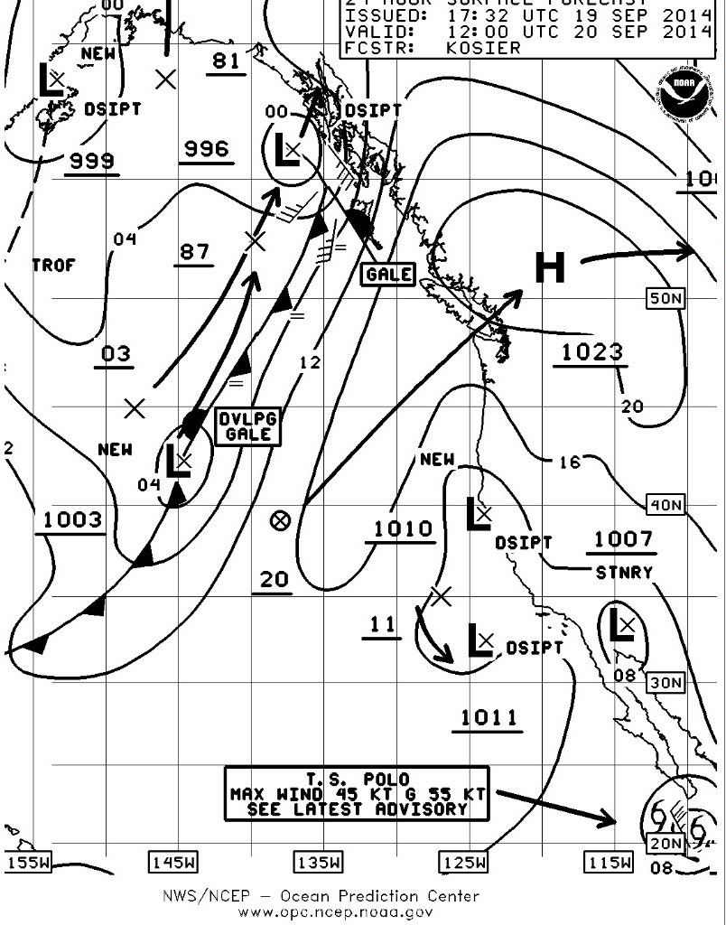
Surface Chart for September 20.
In a nutshell, the last weekend of summer is going to be spectacular on the water. For the sailors doing the TransPuget you may actually get to go across the Sound and the regatta in the Lake and up in Bellingham Bay should also get just about perfect conditions at least for Saturday.
You probably noticed the cloudy conditions midweek with even a bit of precip around as a weak low pressure system blew through the area. Following the traditional pattern, the first day that the ridge of high pressure establishes itself will be the best and strongest breeze and it will be from the north on the Sound and from the northwest in Bellingham Bay. As the day goes on, the breeze should back to the Northwest on the Sound and increase slightly in velocity. The increase will be in proportion to how much overcast there is in the morning, how fast it burns off in the mid day and how fast the heat sink that is the concrete and asphalt jungle they call Seattle heats up and draws the breeze down the Sound.
The other factor the breeze on the Sound has going for it is the slack tide at 0932 at West Point with max flood developing at 1228 and then returning to slack at 1551 which should have pretty much everyone done with racing. The fact that it’s flooding will help bring the breeze down the Sound, the Swihart Effect.
Dew Point
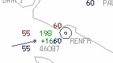
For you cruisers, you should watch Sunday morning as the high starts to break up as another series of disturbances start to move towards the Pacific Northwest. There is a chance of patchy morning fog so pay attention to the dew point which you can get off of the U of W surface observations chart. I’ve attached the 1400 hr surface observations (Friday) at the mouth of the Straits showing Buoy JA (46087) and Port Renfrew. The current temperature is the red number in the upper left hand corner above the station with dew point being the blue number in the lower left hand corner below the station. In both cases you see that current temperature matches dew point and there is very little wind all of which means that conditions are perfect for the formation of fog.

Sea Surface Temperature, Anomaly Global Analysis.
After last week I had a couple of emails and phone calls (thank you) asking about the seemingly warmer than normal temperatures and how late this Indian summer has lasted. The answer can be found on the NOAA Current Operational SST Anomaly Charts For the Year 2014, which is probably something you should keep an eye on. This is the Sea Surface Temperature Anomaly Chart which shows how much above or below the average temperature is on the ocean surface. It’s also a great way to figure out how far offshore you may have to go to find albacore tuna. You’ll notice that right to our west is a huge area of very warm water some 4-5 degrees(C) warmer than normal. This amorphous blob has had a profound effect upon our weather this summer and as you go back through the months you’ll see it hasn’t moved very much or changed very much. In the long range this will probably keep our temps above normal and our rainfall above normal because remember that warm air holds more moisture than cold air so as air masses get pushed over this area in the normal flow of things this will they will acquire more moisture. Then as the air masses encounter land they rise to go over the mountains, cool, and then because cold air can’t hold as much moisture, it gets released as rain. So more rain and warmer than normal temps will be in play for the fall and winter. Great for sailing because sailors don’t care about how wet it is as long as there’s wind and bad for skiers who may find the snow fall less than normal.

Tropical Storm Polo
Then there’s Tropical Storm Polo (all together everyone yell MARCO). Pretty much all the models have it curving away from Baja however don’t underestimate the amount of rain that may hit the area from Cabo to La Paz, a mountainous area with water saturated soil making the conditions ripe for additional slides. If Cabo or that area is in your holiday travel plans you may want to reconsider as the infrastructure will not get rebuilt that quickly there. Call ahead and make sure before you go.
Have a great weekend!