


Dear Northwest Yachting,
On page 45 of your October issue in an article “Alaska Bound – Part 16,” Marianne Scott wrote: “Retracing our route through Grenville Chan- nel, we opted to anchor in highly protected Baker Inlet. . . The chart needs updating as our GPS had us traversing the channel over land.”
We at the Canadian Hydrographic Service (CHS) are always anxious to follow up any issues with CHS products that may compromise the safety of anyone using our charts. We are therefore anxious to determine:
*What chart was being used at the time? Is this a CHS product or something else?
* What evidence is there to suggest the chart is at fault? Although based on older data we have checked our product and cannot find the problem being reported. It is possible that there were other factors such as high terrain interfering with GPS reception.
Over the years I have followed up a number of similar issues. While some do prove to be valid concerns, it is more often the case that the chart is blamed for poor navigation, faulty equipment or other reasons. I am also surprised that people do not follow up by contacting us. If they believe they have identified an important safety concern that may put others in danger, they need to follow up to help prevent possible future accidents. This is an important message that needs to be communicated to boaters at every opportunity.
Hope this helps and look forward to hearing from you if any further information about this potentially dangerous incident can be forwarded.
Dave Jackson
Canadian Hydrographic Services
Mr. Jackson’s message was forwarded to Marianne Scott, who replied:
Dear Mr. Jackson,
About our entry into Baker Inlet from Grenville Channel, let me an- swer your questions.
We use Coastal Explorer electronic charts. They base their Canadian charts on the CHS.
I’ve reviewed with my husband the circumstances of the entry to Baker Inlet. This is what we recall:
*The entrance is narrow and drains a large inlet.
*We went into an ebbing tide with at least 3.5 knots of current against us.
*The water was highly turbulent.
*The GPS reported we were moving over land on the port (north) side.
*There are some hills around the inlet, but nothing too high, especially after experiencing high mountains during a 3.5 month trip to Alaska and through some of BC’s fjords.
*We believe our GPS is OK as this is the only time we moved over land during this long voyage.
*We don’t believe this was poor navigation.
You are right that we should have contacted you about this anomaly. We will do so in the future if we run into a similar problem. Baker Inlet is not easy to get into and might be skipped by others who are sailing in this area. This may account for it not being reported before.
I hope this answers your questions.
Marianne Scott
Hello again Marianne,
All the best of the season to you from a very rainy day in Pat Bay. My apologies for not getting a response to you a litt le earlier but I wanted to take the time to ensure we did a thorough investigation. We have double checked our chart data in Baker Inlet against independent sources and can find no significant problem with it. Certainly nothing that would explain why a GPS equipped vessel would appear transiting across dry land.
If you refer to the image attached we have overlain the CHS chart on top of a geo-referenced aerial photo- graph. Typically these images have a horizontal data accuracy of about 2 metres. As you can see the match is very good which indicates to us that the problem reported is not due to the chart but lies elsewhere. GPS is very good and we have all become very reliant upon it. 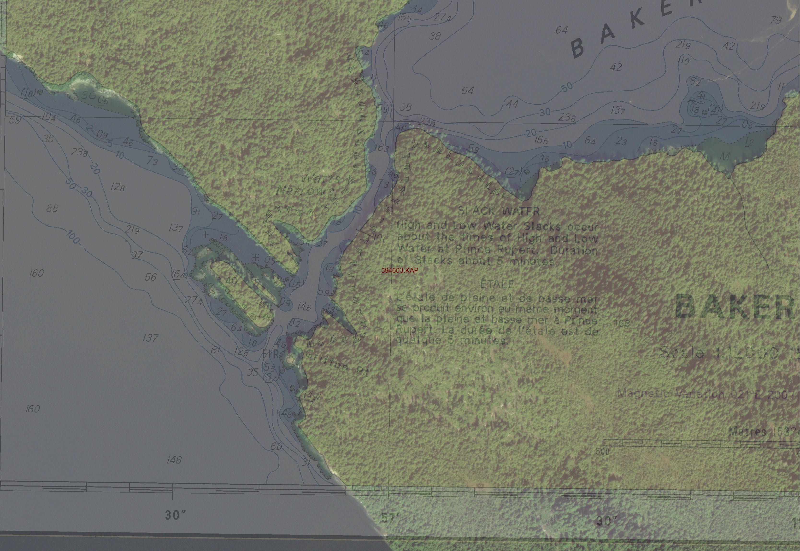 However, there are problems such as terrain masking, multipath and other errors that do occur, and people may not be familiar with them. A prudent navigator will never rely on a single source of information for positioning and should always use all tools available. We also should all be aware of the different navigation tools that we use and their strengths and weaknesses.
Lastly I would like all boaters to know that we appreciate any client feedback that can help us improve our products and safety to navigation. If anyone does have any information then I would urge them to contact CHS through our website www.charts.gc.ca/index-eng.asp
Dave Jackson
Canadian Hydrographic Services
It’s great to see this kind of cooperation between our writer and the hydrographic experts. Thanks to Marianne for taking such copious notes. We will post the image mentioned on nwyachting.com. Readers, feel free to send us your navigational concerns and we’ll get them to the right authorities.